Victorian Resources Online (archived)
GP52
| Location: Bass Hill | Aust. Soil Class.: Basic, Lithic, Bleached-Orthic TENOSOL |
| General Landscape Description: Midslope of hill (18% slope) (north-north easterly aspect) | |
| Geology: Cretaceous sediments. | |
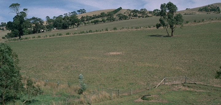 GP52 Landscape |
Soil Profile Morphology:
Surface Soil
| A1 | 0-20 cm | Very dark greyish brown (10YR3/2); fine sandy clay loam; hardsetting surface condition; weak blocky, parting to moderate coarse blocky structure; very firm consistence dry; pH 5.9; clear change to: | 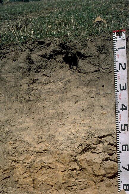 GP52 Profile |
| A2 | 20-40 cm | Yellowish brown (10YR5/4) bleached (10YR7/3d); fine sandy loam; massive to weak coarse blocky structure; firm consistence dry; pH 5.5; gradual change to: | |
| Subsoil | |||
| B21 | 40-65 cm | Light yellowish brown (10YR6/4) with fine yellowish brown (10YR5/8) mottles; sandy loam; weakly structured; firm consistence dry; pH 5.8; smooth and wavy change to: | |
| C | 65+ cm | Sandstone. | |
Key Profile Features:
- Hardsetting surface condition.
- The profile has a high fine sand content (>40%) throughout.
- The subsurface (A2) horizon is bleached.
pH | Salinity Rating | |||
Surface (A1 horizon) | Moderately Acid | Very Low | Non-Sodic | - |
Subsoil (B21 horizon) | Moderately Acid | Very Low | Non-Sodic | - |
|
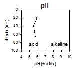
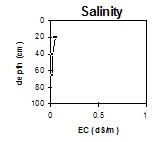
Horizon | Horizon Depth | pH (water) | pH CaCl2 | EC 1:5 | NaCl | Exchangeable Cations | |||
Ca | Mg | K | Na | ||||||
Meq/100g | |||||||||
A1 | 0-20 | 5.9 | 5.1 | 0.05 | 6.5 | 1.1 | 0.23 | 0.16 | |
A2 | 20-40 | 5.5 | 4.7 | <0.05 | 2.1 | 0.48 | 0.07 | 0.11 | |
B21 | 40-65 | 5.8 | 4.9 | <0.05 | 3.5 | 1.1 | 0.1 | 0.12 | |
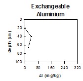
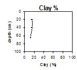
Horizon | Horizon Depth | Ex Al mg/kg | Ex Ac meq/100g | Wilting Point pF4.2 g/100g | Coarse Sand (0.2-2.0mm) % | Fine Sand (0.02-0.2mm) % | Silt (0.002-0.02mm) % | Clay (<0.002mm) % |
A1 | 0-20 | <10 | 10 | 9.3 | 9 | 42 | 27 | 16 |
A2 | 20-40 | 40 | 7.7 | 6.8 | 8 | 46 | 29 | 16 |
B21 | 40-65 | 23 | 5.1 | 6.7 | 10 | 54 | 25 | 13 |
Management Considerations:
Surface (A) Horizons
- The surface soil is hardsetting and requires organic matter for maintaining soil aggregation. Currently, organic matter levels are moderate but this will decline if cropping takes place and can be improved by adopting practices such as residue retention, minimum tillage and utilising pasture rotations.
- The inherent fertility of the surface (A1) horizon (based on the sum of the exchangeable calcium, magnesium and potassium cations) is low. The nitrogen levels are moderate.
- The subsoil has a relatively low inherent fertility throughout (based on the sum of the exchangeable basic cations).