Victorian Resources Online (archived)
GP55
| Location: Kernot | Aust. Soil Class.: Acidic, Eutrophic, Grey DERMOSOL |
| General Landscape Description: Crest of rolling hill on a dissected peneplain. | |
| Geology: Cretaceous sediments. | |
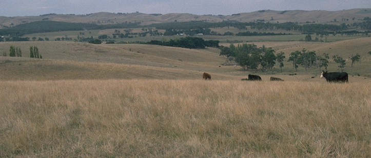 GP55 Landscape |
Soil Profile Morphology:
Surface Soil
| A11 | 0-15 cm | Very dark greyish brown (10YR3/2); very fine sandy clay loam; massive structure; firm consistence dry; pH 5.1; clear change to | 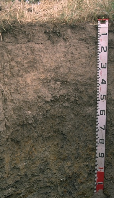 GP55 Profile |
| A12 | 15-35 cm | Dark brown (10YR3/3) with few (8%) brownish yellow (10YR6/8) mottles; very fine sandy clay loam; weak to moderate coarse polyhedral structure; very firm consistence dry; pH 5.1; gradual change to | |
| Subsoil | |||
| B1 | 35-50 cm | Dark greyish brown (10YR4/2) with dark yellowish brown (10YR4/6) mottles; conspicuously bleached in patches fine sandy clay loam; moderate coarse prismatic, parting to moderate coarse blocky structure; very firm consistence dry; pH 5.2; clear and wavy change to | |
| B21 | 50-70 cm | Dark greyish brown (10YR4/2) with common (15%) brownish yellow (10YR6/8) mottles; light medium clay; strong coarse prismatic, parting to moderate blocky structure; pH 5.4; gradual and wavy change to | |
| B22 | 70-100 cm | Greyish brown (10YR5/2) with many (25%) brownish yellow (10YR6/8) mottles; light medium clay; strong coarse prismatic, parting to moderate blocky structure; very firm consistence dry; pH 5.4 | |
| C | 100+ cm | Cretaceous mudstone | |
Key Profile Features:
- Lack of strong texture contrast between surface (A) horizons of subsoil (B21) horizons.
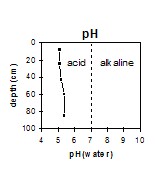
pH | Salinity Rating | |||
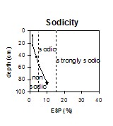
Surface (A1 horizon) | Strongly Acid | Very Low | Non-Sodic | - |
Subsoil (B21 horizon) | Strongly Acid | Very Low | Sodic | None1 |
Deeper Subsoil (at 1 m) | Strongly Acid | Very Low | Sodic | None2 |
2 complete dispersion after remoulding
|
Horizon | Horizon Depth | pH (water) | pH CaCl2 | EC 1:5 | NaCl | Exchangeable Cations | |||
Ca | Mg | K | Na | ||||||
Meq/100g | |||||||||
A11 | 0-15 | 5.1 | 4.2 | 0.08 | 3.9 | 2.7 | 0.56 | 0.55 | |
A12 | 15-35 | 5.1 | 4 | 0.07 | 2.3 | 2.5 | 0.32 | 0.59 | |
B1 | 35-50 | 5.2 | 4 | 0.07 | 1.3 | 4 | 0.31 | 0.94 | |
B21 | 50-70 | 5.4 | 4 | 0.07 | 1.3 | 6.2 | 0.47 | 1.6 | |
B22 | 70-100 | 5.4 | 4.1 | 0.11 | 2.6 | 13 | 0.63 | 3.6 | |
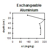
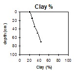
Horizon | Horizon Depth | Ex Al mg/kg | Ex Ac meq/100g | Wilting Point pF4.2 g/100g | Coarse Sand (0.2-2.0mm) % | Fine Sand (0.02-0.2mm) % | Silt (0.002-0.02mm) % | Clay (<0.002mm) % |
A11 | 0-15 | 150 | 19 | 12.5 | 4 | 24 | 45 | 21 |
A12 | 15-35 | 320 | 18 | 11.2 | 1 | 24 | 46 | 25 |
B1 | 35-50 | 270 | 15 | 14.2 | 1 | 22 | 43 | 31 |
B21 | 50-70 | 280 | 17 | 17 | 1 | 20 | 40 | 37 |
B22 | 70-100 | 280 | 16 | 24.4 | 1 | 16 | 36 | 44 |
Management Considerations:
Whole Profile
- Much of the soil profile is strongly acid. As a result, deficiencies in molybdenum, potassium and phosphorus may occur. Manganese toxicity may also occur in strongly acid soils, particularly when poorly drained (as waterlogging may bring manganese into solution). Levels of exchangeable aluminium measured are very high throughout the profile (i.e. ranging from 150 to 320 mg/kg within the surface (A) horizons). This is likely to restrict the growth of aluminium sensitive species. A pH/aluminium test sampled across the paddock would be most appropriate to determine how much lime is needed to raise soil pH. However, other factors need to be considered before lime is recommended (e.g. pasture species grown, method of application, local trial responses, soil surface structure and likely cost/benefit).
- The inherent fertility of the surface (A1) horizon (based on the sum of the exchangeable calcium, magnesium and potassium cations) is low. The high levels of organic matter at this site are important for improving soil fertility, water holding capacity and enhancing surface soil structure.
- The dense and coarsely structured upper subsoil (B21) horizon is sodic and has a low exchangeable calcium to magnesium ratio (0.2). However, strong dispersion only occurs after remoulding. The high levels of exchangeable aluminium (280 mg/kg) in the subsoil may be the cause of the restricted dispersion. The subsoil is dense and coarsely structured which will restrict root movement down the profile.