Victorian Resources Online (archived)
GP56
| Location: Kernot | Aust. Soil Class.: Bleached, Mesotrophic, Brown KUROSOL (thick sandy surface) |
| General Landscape Description: Crest (6% slope) of a hillslope of rolling hill. Original vegetation includes messmate | |
| Geology: Tertiary sediments. | |
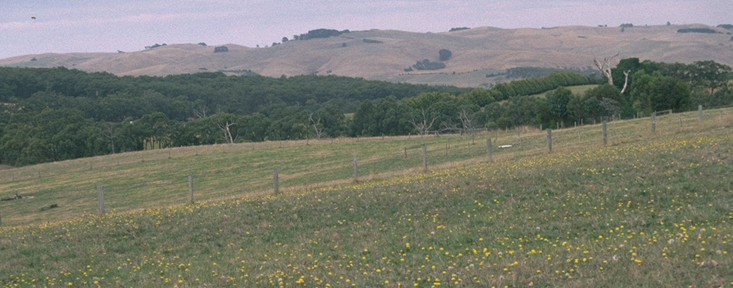 GP56 Landscape |
Soil Profile Morphology:
Surface Soil
| A1 | 0-15 cm | Very dark grey (10YR3/1); loamy sand (organic); firm surface condition; weak structure; weak consistence dry; pH 4.7; clear change to: | 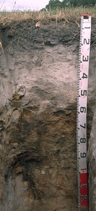 GP56 Profile |
| A21 | 15-40 cm | Brown (7.5YR5/2) bleached (7.5YR7/2d); loamy sand; massive structure; very weak consistence dry; pH 5.0; clear and wavy change to: | |
| A22 | 40-55 cm | Brown (7.5YR5/2) bleached (7.5YR7/2d); loamy sand; massive structure; very firm consistence dry; patches of cemented sand present; pH 5.0; abrupt change to: | |
| Subsoil | |||
| B21 | 55-90 cm | Brown (7.5YR4/4); sandy clay loam; massive structure; firm consistence dry; contains a few (10%) subrounded iron concretions (40 mm in size), as well as a few (2-10%) sandstone fragments (2-6 mm in size) in gravel patches cemented by iron; pH 5.1; clear change to: | |
| B22 | 90+ cm | Dark red (2.5YR4/6) with reddish yellow (7.5YR6/8) and pinkish grey (7.5YR7/2) mottles; very dark greyish brown (10YR3/2) stains down root channels; coarse sandy clay loam; moderate coarse polyhedral structure; sandstone (2-6 mm in size) gravel common (15-20%) in patches; pH 5.3. | |
Key Profile Features:
- Thick sandy surface horizons (to 55 cm depth)
- Strong texture contrast between sandy surface (A) horizons and subsoil (B21) horizon
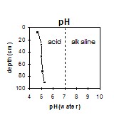
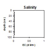
pH | Salinity Rating | |||
Surface (A1 horizon) | Very Strongly Acid | Very Low | Non-Sodic | - |
Subsoil (B21 horizon) | Strongly Acid | Very Low | Sodic | - |
Deeper Subsoil (at 1 m) | Strongly Acid | Very Low | Sodic | - |
|
Horizon | Horizon Depth | pH (water) | pH CaCl2 | EC 1:5 | NaCl | Exchangeable Cations | |||
Ca | Mg | K | Na | ||||||
Meq/100g | |||||||||
A1 | 0-15 | 4.7 | 3.6 | <0.05 | 2.1 | 0.8 | 0.11 | 0.14 | |
A21 | 15-40 | 5 | 3.9 | <0.05 | 0.66 | 0.14 | <0.05 | 0.06 | |
A22 | 40-55 | 5 | 4.1 | <0.05 | 0.4 | <0.05 | <0.05 | <0.05 | |
B21 | 55-90 | 5.1 | 4.2 | <0.05 | 1 | 0.54 | 0.28 | 0.13 | |
B22 | 90+ | 5.3 | 4.4 | <0.05 | 1.7 | 2.6 | 0.36 | 0.17 | |
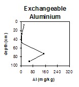
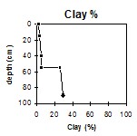
Horizon | Horizon Depth | Ex Al mg/kg | Ex Ac meq/100g | Wilting Point pF4.2 g/100g | Coarse Sand (0.2-2.0mm) % | Fine Sand (0.02-0.2mm) % | Silt (0.002-0.02mm) % | Clay (<0.002mm) % |
A1 | 0-15 | 21 | 12 | 4.8 | 33 | 48 | 13 | 2 |
A21 | 15-40 | <10 | 2.7 | 1.3 | 34 | 49 | 12 | 3 |
A22 | 40-55 | <10 | 1.5 | 1.2 | 31 | 47 | 15 | 5 |
B21 | 55-90 | 150 | 11 | 10 | 41 | 24 | 7 | 26 |
B22 | 90+ | 57 | 8.1 | 11.7 | 60 | 7 | 3 | 29 |
Management Considerations:
Whole Profile
- The soil profile ranges from very strongly acid in the surface to strongly acid in the subsoil. As a result, deficiencies in molybdenum, potassium and phosphorus may occur. Manganese toxicity may also occur in strongly acid soils, particularly when poorly drained (as waterlogging may bring manganese into solution). Levels of exchangeable aluminium measured are not high within the sandy surface soil (ie. 21 mg/kg) but does increase in the subsoil. A pH/aluminium test sampled across the paddock may be appropriate to determine whether lime is needed to raise soil pH. However, other factors need to be considered before lime is recommended (e.g. pasture species grown, method of application, local trial responses, soil surface structure and likely cost/benefit).
- The inherent fertility of the surface (A1) horizon (based on the sum of the exchangeable calcium, magnesium and potassium cations) is very low. The high Organic matter is important for improving soil fertility, water holding capacity and enhancing surface soil structure on soils such as these.
- The sandy surface horizons (47-49%) have a very low water holding capacity. The low wilting point (5%) of the surface (A1) horizon indicates that plants will be able to utilise very light rains when the soil is dry. However, due to the low water storage capacity, plants will soon suffer moisture stress unless further rain falls occur.
- The subsoil is strongly acid. The exchangeable aluminium levels are quite high (150 mg/kg) but will effect only deeper rooted aluminium sensitive species (> 55 cm depth).
- The subsoil has a very low inherent fertility (based on the sum of the exchangeable basic cations).