Victorian Resources Online (archived)
GP58
| Location: Richardson Hill | Aust. Soil Class.: Vertic, Mottled-Subnatric, Brown SODOSOL |
| General Landscape Description: Lower midslope of down hill (10% slope). | Geology: Tertiary basalt. |
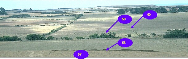
GP57-GP60 Landscape
Soil Profile Morphology:
Surface Soil
| A11 | 0-15 cm | Very dark greyish brown (10YR3/2); fine sandy clay loam; moderate medium polyhedral, parting to fine structure; very firm consistence dry; pH 5.6; gradual change to: | 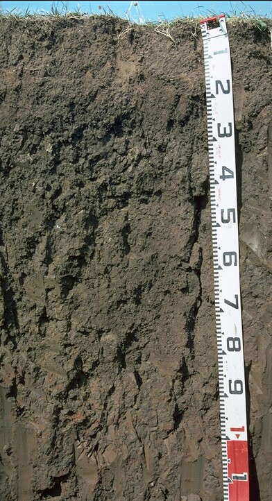 GP58 Profile |
| A12 | 15-25 cm | Dark brown (10YR3/3); clay loam; moderate medium polyhedral, parting to strong fine polyhedral structure; firm consistence dry; pH 6.2; abrupt change to: | |
| Subsoil | |||
| B21 | 25-80 cm | Dark brown (10YR3/3) with faint brownish yellow (10YR6/6) mottles; heavy clay; moderate very coarse polyhedral, parting to strong coarse polyhedral, blocky structure; slickensides with highly polished clay skins evident; strong consistence moist; pH 6.6; gradual change to: | |
| B22 | 80+ cm | Dark greyish brown (10YR4/2) with red (2.5YR5/8) mottles; heavy clay; slickensides evident; strong consistence moist; pH 5.3. | |
Key Profile Features:
- Vertic properties present within the subsoil i.e. slickensides.
pH | Salinity Rating | |||
Surface (A1 horizon) | Moderately Acid | Low | Non-Sodic | Slight |
Subsoil (B21 horizon) | Sightly Acid | Very Low | Marginally Sodic | None |
Deeper subsoil (at 80 cm) | Strongly Acid | Very Low | Sodic | None |
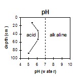 The surface horizon is moderately acid. The upper subsoil is slightly acid becoming strongly acid at 80 cm depth. | 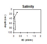 The salinity rating in the surface horizon is low becoming very low in the subsoil. | 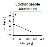 The exchangeable aluminium levels in the surface horizons are negligible becoming very high at 80 cm depth. | 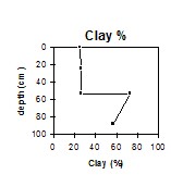 The clay content increases abruptly at the A/B boundary. |
Horizon | Horizon Depth | pH (water) | pH CaCl2 | EC 1:5 | NaCl | Exchangeable Cations | |||
Ca | Mg | K | Na | ||||||
Meq/100g | |||||||||
A11 | 0-15 | 5.6 | 4.9 | 0.13 | 6.5 | 3.1 | 0.74 | 0.56 | |
A12 | 15-25 | 6.2 | 5.1 | 0.05 | 5.5 | 4.1 | 0.19 | 0.61 | |
B21 | 25-80 | 6.6 | 5.5 | 0.07 | 6.3 | 10 | 0.26 | 1.6 | |
B22 | 80+ | 5.3 | 4.4 | 0.18 | 4.3 | 12 | 0.24 | 3.2 | |
Horizon | Horizon Depth | Ex Al mg/kg | Ex Ac meq/100g | Wilting Point pF4.2 g/100g | Coarse Sand (0.2-2.0mm) % | Fine Sand (0.02-0.2mm) % | Silt (0.002-0.02mm) % | Clay (<0.002mm) % |
A11 | 0-15 | <10 | 10 | 18.4 | 8 | 26 | 32 | 25 |
A12 | 15-25 | <10 | 8.8 | 14.1 | 5 | 29 | 32 | 29 |
B21 | 25-80 | <10 | 9.9 | 27 | 2 | 13 | 14 | 67 |
B22 | 80+ | 230 | 14 | 27.8 | 2 | 15 | 17 | 64 |
Management Considerations:
Surface (A) Horizons
- The inherent fertility of the surface (A1) horizon (based on the sum of the exchangeable calcium, magnesium and potassium cations) is moderate. The high levels of organic matter at this site are important for improving soil fertility, water holding capacity and enhancing surface soil structure. The nitrogen levels are also high. Planting legumes may help to alleviate the low fertility deficiency.
- The surface (A1) horizon is non-sodic but disperses slightly. This indicates that tillage or over-stocking of the soil whilst in a moist to wet condition may result in structural degradation (e.g. surface sealing, increased cloddiness) occurring. Raindrop action on bare soil may have a similar effect, so it is important to maintain surface cover. Gypsum application may assist in improving surface soil structural condition on such soils.
- The subsoil has a moderate inherent fertility throughout (based on the sum of the exchangeable basic cations).
- The presence of mottling throughout the subsoil indicates that the profile is seasonally waterlogged.
- The subsoil has vertic properties i.e. slickensides which indicates that significant shrinking and swelling occurs during wetting-drying cycles. This can disrupt the roots of perennial plants and will have implications for engineering applications (e.g. building foundations and fence lines).
- The dense and coarsely structured upper subsoil (B21) horizon is sodic and has a low exchangeable calcium to magnesium ratio (0.7). However, no dispersion occurs which is beneficial to root growth. Interestingly, roots were observed to 60 cm depth.
- At 80 cm depth the soil becomes strongly acid and the exchangeable aluminium levels very high at 230 mg/kg. Only deep rooted plants would be effected.