Victorian Resources Online (archived)
GP60
| Location: Richardson Hill. | Australian Soil Classification: Endoacidic-Mottled, Epipedal, Brown VERTOSOL. |
| Geology: Basalt. | General Landscape Description: Edge of a depression or a low lying area (0-1% slope). |
| Mapping Unit: Merricks Clay. | |
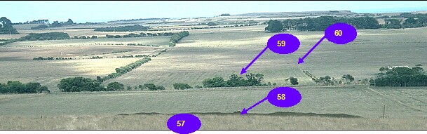 GP57-GP60 Landscape |
Soil Profile Morphology:
Surface Soil
| A1 | 0-10 cm | Brown (10YR4/3); light medium clay; surface cracking (up to 2 cm wide); moderate medium polyhedral structure; strong consistence dry; pH 5.7: | 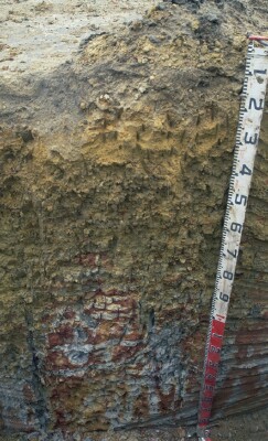 Site GP60 Profile |
| Subsoil | |||
| B21 | 10-20 cm | Brown (10YR4/3); medium clay; strong medium polyhedral, parting to fine structure; strong consistence dry; pH 5.9: | |
| B22 | 20-30 cm | Very dark greyish brown (10YR3/2); rusty root channel mottling evident; heavy clay; strong coarse prismatic, parting to strong fine polyhedral, parting to coarse blocky structure; firm consistence moist; pH 5.7: | |
| B23 | 30-80 cm | Dark brown (10YR3/3) with faint yellowish brown (10YR5/6) mottles; heavy clay; weak consistence wet; slickensides evident; pH 4.7: | |
| B24 | 80 + cm | Greyish brown (10YR5/2) with yellowish brown (10YR5/6) mottles; heavy clay; firm consistence wet; pH 4.4. | |
Key Profile Features:
- Surface cracking present.
- Clay texture throughout the soil profile.
- Vertic properties present within the subsoil i.e. slickensides.
Horizon | pH | Salinity Rating | ||
Surface (A1 horizon) | Moderately Acid | Moderate | Non-Sodic | None |
Subsoil (B21 horizon) | Moderately Acid | High | Non-Sodic | None1,2 |
Deeper subsoil (at 90 cm) | Extremely Acid | High | Sodic | None,2 |
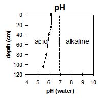 | 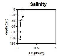 | 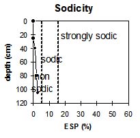 | 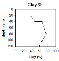 |
The surface horizon is moderately acid becoming extremely acid at 80 cm depth. | The salinity levels of the surface horizon is moderate becoming high in the subsoil. | The exchangeable aluminium levels in the surface are negligible becoming high at about 40 cm and very high at 80 cm. | The clay content increases gradually with depth then drops marginally. |
Horizon | Horizon Depth (cm) | pH (water) | pH (CaCl2) | EC 1:5 | NaCl | Exchangeable Cations | |||
Ca | Mg | K | Na | ||||||
meq/100g | |||||||||
A1 | 0-10 | 5.7 | 5.3 | 0.67 | 0.1 | 16 | 12 | 0.6 | 1 |
B21 | 10-20 | 5.9 | 5.5 | 0.97 | 0.19 | 13 | 12 | 0.9 | 1.4 |
B22 | 20-30 | 5.7 | 5.4 | 1.3 | 0.31 | 9.7 | 14 | 0.9 | 2 |
B23 | 30-80 | 4.7 | 4.5 | 1.7 | 8 | 17 | 0.7 | 2.4 | |
B24 | 80+ | 4.4 | 4.1 | 1.7 | 0.41 | 4 | 11 | 0.3 | 1.9 |
Horizon | Horizon Depth (cm) | Exchangeable Aluminium mg/kg | Exchangeable Acidity meq/100g | Field Capacity pF2.5 | Wilting Point pF4.2 | Coarse Sand (0.2-2.0 mm) | Fine Sand (0.02-0.2 mm) | Silt (0.002-0.02 mm) | Clay (<0.002 mm) |
A1 | 0-10 | <10 | 18 | 29 | 10 | 11 | 0 | 39 | |
B21 | 10-20 | <10 | 16 | 26 | 3 | 15 | 20 | 49 | |
B22 | 20-30 | <10 | 5.5 | 30 | 1 | 10 | 12 | 66 | |
B23 | 30-80 | 130 | 15 | 35 | 1 | 6 | 7 | 76 | |
B24 | 80+ | 240 | 6.2 | 28 | 1 | 13 | 14 | 66 |
Management Considerations:
Whole Profile
- Below the surface horizons the soil profile has a high level of soluble salts throughout. This is likely to restrict the growth of any salt-sensitive species.
- When the soil is dry, heavy rains will move down soil cracks. This rapid recharge can be valuable for the survival of plants near wilting point. When wet, the soil will swell and further infiltration of water will be relatively slow.
- The high wilting point value (i.e. 29%) indicates that plants will be unable to utilise light rains when the soil is relatively dry.
- The level of soluble salts in the surface is moderate and may restrict the growth of salt sensitive species.
Subsoil (B) Horizon
- The high levels of soluble salts will affect salt-sensitive species from 10 cm depth.
- The subsoil below the B21 horizon is sodic with a low exchangeable calcium to magnesium ratio (0.7) but has no dispersion. Lack of dispersion is probably due to the high salinity levels and will result in less restricted water movement down the profile.
- The presence of mottling throughout the subsoil indicates that the profile is seasonally waterlogged.
- The deeper subsoil (B23) has vertic properties i.e. slickensides which indicates that significant shrinking and swelling occurs during drying-wetting cycles. This can disrupt the roots of perennial plants and will have implications for engineering applications (e.g. building foundations and fence lines).
- From 30 cm the subsoil becomes extremely acid with high exchangeable aluminium levels that will restrict the growth of aluminium-sensitive species.