Victorian Resources Online (archived)
PPW3
| Location: Leakes Road, Rockbank | |
| Aust. Soil Class.: Haplic, Eutrophic, Red DERMOSOL | |
| General Landscape Description: Midslope of 500 m east of summit of Mt Kororoit | |
| Site Description: Grassland currently used for grazing | |
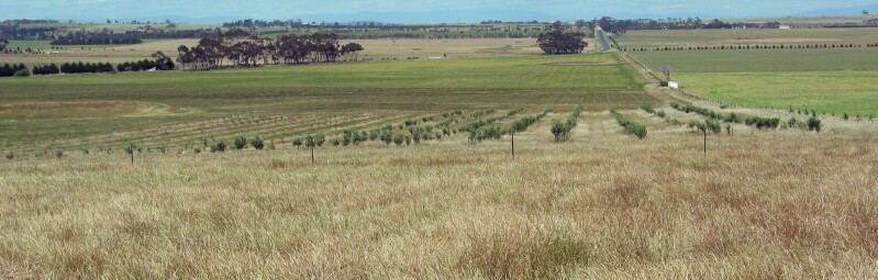 PPW1-3 Landscape |
Soil Profile Morphology:
Surface Soil
| A1 | 0-10 cm | Dark red (2.5YR4/6); fine sandy clay loam; moderate to strong fine granular structure; weak consistence (moist); pH 5.6; clear change to: | 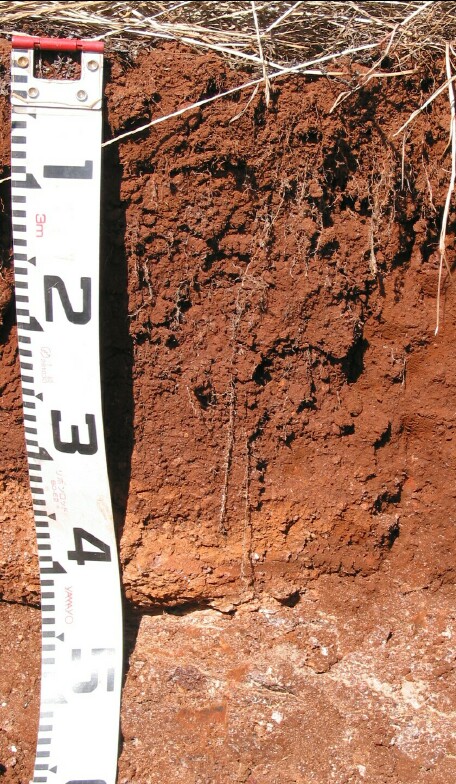 PPW3 Profile |
| Subsoil | |||
| B21 | 10-25 cm | Dark red (2.5YR4/6); light clay; strong medium-fine-very fine blocky structure; weak consistence (moist); pH 6.6; clear change to: | |
| B22 | 25-40 cm | Dusky red (2.5YR4/4); light fine sandy clay; strong medium-fine-very fine blocky structure; weak consistence (moist); scoria (5-15 cm); few manganese flecks associated with scoria (2-5%); pH 7.5: | |
| C | 40+ cm | Layer of scoria and precipitated carbonate. | |
Key Profile Features:
Soil Profile Characteristics:
pH | Salinity Rating | |||
Surface (A1 horizon) | Moderately Acid | Low | Non-Sodic | |
Subsoil (B21 horizon) | Slightly Acid | Low | Non-Sodic | |
Deeper subsoil (at 25-40 cm) | Slightly Alkaline | Low | Non-Sodic |
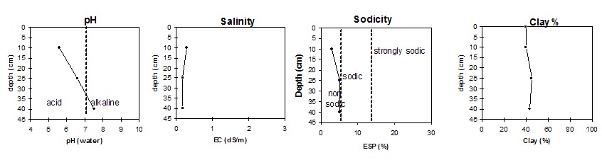 |
Horizon | Horizon Depth | pH (water) | pH CaCl2 | EC 1:5 | NaCl | Exchangeable Cations | |||
Ca | Mg | K | Na | ||||||
Meq/100g | |||||||||
A1 | 0-10 | 5.6 | 5.1 | 0.28 | 0.03 | 8.0 | 3.6 | 4.7 | 0.4 |
B21 | 10-25 | 6.6 | 6.1 | 0.17 | 9.7 | 0.83 | 2.0 | 0.83 | |
B22 | 25-40 | 7.5 | 7.0 | 0.18 | 12 | 1.1 | 1.6 | 1.1 | |
Horizon | Horizon Depth | Ex Al mg/kg | Ex Ac meq/100g | Field pF2.5 g/100g | Wilting Point pF4.2 g/100g | Coarse Sand (0.2-2.0mm) % | Fine Sand (0.02-0.2mm) % | Silt (0.002-0.02mm) % | Clay (<0.002mm) % |
A1 | 0-10 | <10 | 16.2 | 25.7 | 20 | 19 | 14 | 40 | |
B21 | 10-25 | 20.7 | 32.0 | 26 | 14 | 13 | 45 | ||
B22 | 25-40 | 21.1 | 34.4 | 28 | 13 | 11 | 43 |