Victorian Resources Online (archived)
GW03
Location: Nyora
Australian Soil Classification: Humose, Humic/Sesquic, Semiaquic PODOSOL
Northcote Factual Key: Uc2.36
Map Unit: Nyora
General Landscape Description: Low hills.
Site Description: Upper slope of a rise slope.
Geology: Neogene sediments (aeolian and riverine).
Land Use: Quarry.
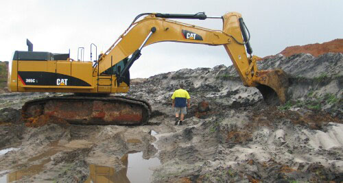
GW03 Landscape
Soil Profile Morphology:
Surface Soil
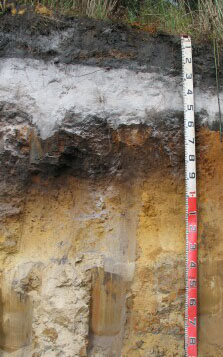
| A1 | 0 – 35 cm | Black (10YR2/1); loamy sand; soft surface condition; apedal; earthy fabric; firm consistence dry; pH 4.2; clear and wavy change to | 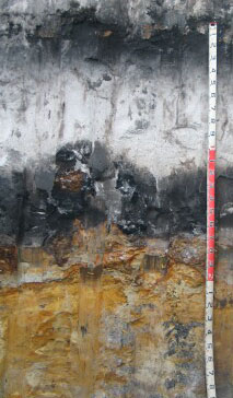 GW03 Profile. 3 metres depth. |
| A2 | 35 – 115 cm | Very pale grey (2.5Y7/1); sand; apedal; granular fabric; weak consistence dry; pH 4.4; clear wavy change to | |
Subsoil | |||
| Bh | 115 – 165 cm | Black (10YR2/1); loamy sand; apedal; earthy fabric; firm consistence moderately moist; pH 3.8; clear and wavy change to: | |
| Bs/Bhs | 165 – 220 cm | Brown (10YR5/3) with many distinct dark brown (10YR3/3) mottles; cemented sand/coffee rock; massive; granular fabric; very strong consistence dry; ferruginised sandstone pan; pH 5.1; clear change to: | |
| C1 | 220 – 300 cm | Brownish yellow (10YR6/4); sand; apedal; granular fabric; firm consistence moderately moist; few ferruginised sandstone; pH 4.5; clear change to:. | |
| C2 | 220 – 300 cm | Brownish yellow (10YR6/4); sand; apedal; granular fabric; firm consistence moderately moist; few ferruginised sandstone; pH 4.5; clear change to: |
GW03 Profile. 2 metres depth.
Shallower profiles occur in different topographic positions.
This profile is about 40m from the described profile.
Key Profile Features:
- Very deep bleached susbsurface horizon.
- Accumulation of organic matter (Bh) and organic matter/iron oxides (Bhs), commonly referred to as “coffee rock”, in deeper subsoil horizons.
Soil Profile Characteristics:
pH | Salinity Rating | |||
Surface (A1 horizon) | Extremely Acid | Low | Non-Sodic | - |
Subsoil (Bh horizon) | Extremely Acid | Very Low | Non-Sodic | - |
Deeper Subsoil (Bs/Bsh horizon) | Strongly Acid | Low | Non-Sodic | - |
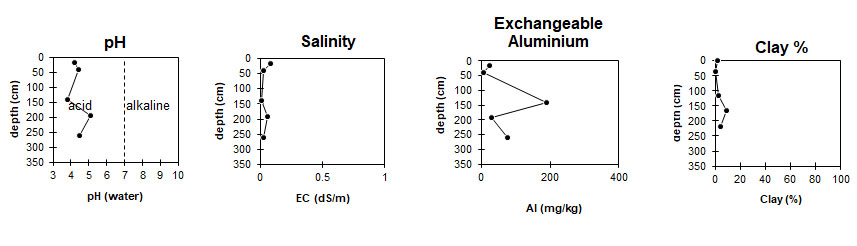
The soil profile is extremely acid. | The level of soluble salts is low to very low throughout the profile. | Aluminium levels are high at 1 metre depth. | Clay levels are low throughout the profile. |
|
Horizon | Horizon Depth (cm) | pH (water) | pH (CaCl2) | EC dS/m | Total Nitrogen g/100g | Organic Carbon g/100g | Exchangeable Cations | |||
Ca | Mg | K | Na | |||||||
Meq/100g | ||||||||||
A1 | 0-35 | 4.2 | 3.5 | 0.08 | 0.22 | 5 | 3.6 | 1.1 | <0.05 | 0.14 |
A2 | 35-115 | 4.4 | 4.2 | <0.05 | <0.05 | <0.05 | <0.05 | <0.05 | <0.05 | |
Bh | 115-165 | 3.8 | 3.2 | 0.006 | 0.98 | 0.11 | 0.32 | <0.05 | 0.08 | |
Bs/Bsh | 165-220 | 5.1 | 4.9 | 0.06 | 0.2 | 0.11 | <0.05 | 0.08 | ||
C1 | 220-300 | 4.5 | 4.3 | <0.05 | <0.05 | 0.08 | <0.05 | 0.06 | ||
C2 | 300-320+ | |||||||||
Horizon | Horizon Depth (cm) | Exchangeable Aluminium mg/kg | Exchangeable Acidity meq/100g | Field Capacitiy pF 2.5 | Wilting Point pF4.2 | Coarse Sand (0.2-2.0mm) % | Fine Sand (0.02-0.2mm) % | Silt (0.002-0.02mm) % | Clay (<0.002mm) % |
A1 | 0-15 | 23 | 22 | 13.9 | 6.7 | 20.5 | 67.8 | 3 | 2 |
A2 | 15-30 | <10 | <1.0 | 2.9 | 0.6 | 27 | 68.8 | 3.5 | 0.5 |
B21 | 30-80 | 190 | 12 | 4.6 | 2.2 | 20 | 75.3 | 0 | 2.5 |
B22 | 80-120 | 30 | 9.3 | 7.6 | 4.8 | 27.4 | 59.8 | 0 | 9.0 |
76 | 2.2 | 3.5 | 2.2 | 19.4 | 75.3 | 0 | 4.0 |
Profile Described By: David Rees (March 2011).