Victorian Resources Online (archived)
Archived content — This page contains material from the Victorian Resources Online (VRO) website. It is no longer maintained and is provided for reference only. This content is hosted by CeRDI and is not endorsed by Agriculture Victoria.
Sitemap
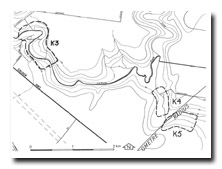
K4 Sydenham Park - Silurian and Tertiary Sediments
|
This information has been developed from the publications:
- Sites of Geological and Geomorphological Significance in the Western Region of Melbourne (1986) by Neville Rosengren
- Sites of Geological and Geomorphological Significance on the Coast of Port Phillip Bay (1988) by Neville Rosengren.
- Sites of Geological and Geomorphological Significance in the Shire of Otway (1984) by Neville Rosengren.
Geological heritage sites, including sites of geomorphological interest and volcanic heritage sites, are under regular revision by the Geological Society of Australia, especially in the assessment of significance and values. Reference should be made to the most recent reports. See the Earth Science Heritage section of the Geological Society of Australia website (external link) for details of geological heritage reports, and a bibliography. |
Location
Access
Ownership | Keilor - 062274. Former City of Keilor. Maribyrnong River valley at northeastern edge of proposed Sydenham Park.
Sydenham Park
Private land (to be developed as public land) | 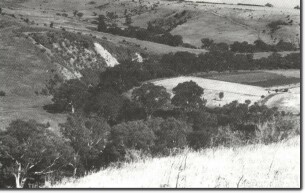
K4 - Newer Volcanics escarpments, Jacksons Creek, Sydenham Park. |
Site Description |
Steeply dipping Silurian sediments from rapids in the river channel at the base of a cliff. Overlying the Silurian are siliceous beds of coarse sand and silcrete, the more resistant siliceous beds forming an escarpment at the cliff top. | |
Significance |
Local. The site is an example of an unconformity, and also shows the influence of resistant beds in determining escarpment development. | |
Management |
Class 2. The site should be kept clear of vegetation and features as a geological site in the Sydenham Park. | |
K4