Victorian Resources Online (archived)
Archived content — This page contains material from the Victorian Resources Online (VRO) website. It is no longer maintained and is provided for reference only. This content is hosted by CeRDI and is not endorsed by Agriculture Victoria.
Sitemap
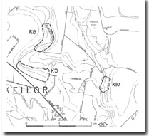
K8 Keilor North - Mairbyrnong River Terraces
|
This information has been developed from the publications:
- Sites of Geological and Geomorphological Significance in the Western Region of Melbourne (1986) by Neville Rosengren
- Sites of Geological and Geomorphological Significance on the Coast of Port Phillip Bay (1988) by Neville Rosengren.
- Sites of Geological and Geomorphological Significance in the Shire of Otway (1984) by Neville Rosengren.
Geological heritage sites, including sites of geomorphological interest and volcanic heritage sites, are under regular revision by the Geological Society of Australia, especially in the assessment of significance and values. Reference should be made to the most recent reports. See the Earth Science Heritage section of the Geological Society of Australia website (external link) for details of geological heritage reports, and a bibliography. |
| Location | Keilor - 263079. Former City of Keilor, Maribyrnong River valley 3 km north of Keilor. | |
Access |
Highland Road |
Ownership |
Private land |
Site Description |
Paired terraces occur along this section of the Maribyrnong River. A shallow depression marks an abandoned river course across both terraces. |
Significance |
Local. The site is a clear example of confined paired terraces. |
Management |
Class 2. The site should be left free from dense tree plantings or construction that would obscure the form of the terraces. |