Victorian Resources Online (archived)
Archived content — This page contains material from the Victorian Resources Online (VRO) website. It is no longer maintained and is provided for reference only. This content is hosted by CeRDI and is not endorsed by Agriculture Victoria.
Sitemap
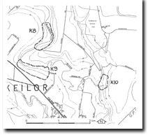
K9 Keilor North - Silcrete
|
This information has been developed from the publications:
- Sites of Geological and Geomorphological Significance in the Western Region of Melbourne (1986) by Neville Rosengren
- Sites of Geological and Geomorphological Significance on the Coast of Port Phillip Bay (1988) by Neville Rosengren.
- Sites of Geological and Geomorphological Significance in the Shire of Otway (1984) by Neville Rosengren.
Geological heritage sites, including sites of geomorphological interest and volcanic heritage sites, are under regular revision by the Geological Society of Australia, especially in the assessment of significance and values. Reference should be made to the most recent reports. See the Earth Science Heritage section of the Geological Society of Australia website (external link) for details of geological heritage reports, and a bibliography. |
Location
Access
Ownership | Keilor - -73250. Former City of Keilor. Southern side of Maribyrnong River 2.5 km northwest of Keilor.
Calder Freeway
Private land | 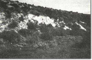
K9 - Silcrete and Newer Volcanics, Jacksons Creek. |
Site Description |
On the southern valley slopes of the Maribyrnong River, a small disused quarry exposes a section of Silurian sediments underlying Older Volcanics basalt. Above the Older Volcanics are sandy sediments, indurated to silcrete, and overlying these are flows of Newer Volcanics basalt. |
Significance |
Regional The site is an example of a geological contact and a substantial outcrop of sub-basaltic silcrete. It is an uncommon example of both Older and Newer Volcanics exposed in the one section. |
Management |
The slope should be left in existing condition to allow display of the geological features described. |
K9