Victorian Resources Online (archived)
Sb1 Red Rock - Eruption Point
|
This information has been developed from the publications:
|
| Location | Sunbury - 917453. Shire of Bulla. Northern side of Western Highway 7 km east of Gisborne. | 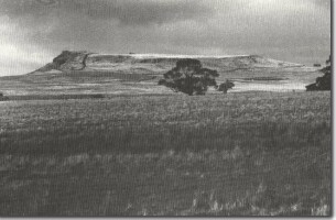 Sb1 - Red Rock, a lava capped eruption point with scoria. |
Access | Dalrymple Road | |
| Ownership | Private land | |
Site Description | Red Rock is a prominent eruption point similar in form to Mt Holden and Mt Aitken, with a more or less flat top surrounded by rock cliffs except, for the eastern side where there is a long gentle slope descending to the surrounding lava plain. There is a scoria rim which has been partly quarries and exposes a section of the red scoria from which the mount derives its name. | |
Significance | Regional. Red Rock is a significant landscape feature of the plains to the east of Gisborne. The hill contains a higher percentage of scoria than normally occurs in the volcanoes of the Gisborne district. | |
| Management | Class 2. The hill should not be subject to residential subdivision above the 450 m contour. |