Victorian Resources Online (archived)
Archived content — This page contains material from the Victorian Resources Online (VRO) website. It is no longer maintained and is provided for reference only. This content is hosted by CeRDI and is not endorsed by Agriculture Victoria.
Sitemap
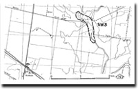
SW3 Rockbank - Kororoit Creek Floodplain
|
This information has been developed from the publications:
- Sites of Geological and Geomorphological Significance in the Western Region of Melbourne (1986) by Neville Rosengren
- Sites of Geological and Geomorphological Significance on the Coast of Port Phillip Bay (1988) by Neville Rosengren.
- Sites of Geological and Geomorphological Significance in the Shire of Otway (1984) by Neville Rosengren.
Geological heritage sites, including sites of geomorphological interest and volcanic heritage sites, are under regular revision by the Geological Society of Australia, especially in the assessment of significance and values. Reference should be made to the most recent reports. See the Earth Science Heritage section of the Geological Society of Australia website (external link) for details of geological heritage reports, and a bibliography. |
| Location | Sydenham West - 950235. Shire of Melton. Valley of Kororoit Creek 2 km northeast of Rockbank. | 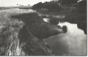
SW3 - Alluvial floodplain sector of Kororoit Creek, Rockbank. |
Access |
Beattys Road. |
Ownership |
Crown land and private land. |
Site Description |
The valley of Kororoit Creek upstream of Beattys Road bridge is a wide floodplain with abandoned stream channels. Below the bridge, the valley narrows and is incised into enclosing lava flows. A small quarry exposes a section in basalt lava flows showing strong platey jointing. |
Significance |
Regional. The site illustrates the influence of lava flows on drainage patterns and show the hydrological complexity of the Kororoit Creek. |
Management |
Class 2. The stream channels in the site should not be artificially modified. The area should be reserved from intensive residential subdivision and retained for open space use. |
 SW3
SW3