Victorian Resources Online (archived)
Archived content — This page contains material from the Victorian Resources Online (VRO) website. It is no longer maintained and is provided for reference only. This content is hosted by CeRDI and is not endorsed by Agriculture Victoria.
Sitemap
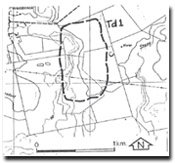
Td1 Teesdale - Dunes
|
This information has been developed from the publications:
- Sites of Geological and Geomorphological Significance in the Western Region of Melbourne (1986) by Neville Rosengren
- Sites of Geological and Geomorphological Significance on the Coast of Port Phillip Bay (1988) by Neville Rosengren.
- Sites of Geological and Geomorphological Significance in the Shire of Otway (1984) by Neville Rosengren.
Geological heritage sites, including sites of geomorphological interest and volcanic heritage sites, are under regular revision by the Geological Society of Australia, especially in the assessment of significance and values. Reference should be made to the most recent reports. See the Earth Science Heritage (external link) section of the Geological Society of Australia website for details of geological heritage reports, and a bibliography. |
Location
| Teesdale - 426843. Former Shire of Bannockburn. Eastern side of Native Hut Creek, 4 km south of Teesdale | |
Access
| Teesdale - Inverleigh Road.
|
| Ownership | Private land. |
Site Description |
Irregular hummocky topography along the Native Hut Creek are remnants of sand dunes and sand sheets. The dunes consist of yellow grey siliceous sand derived apparently from the Moorabool Viaduct Sand during an arid phase. |
Significance |
Regional. Although sand deposits are extensive between Bannockburn and Inverleigh, most have little topographic expression. This site represents one of the few where the dunes form ridges. |
Management |
Class 2. The dunes should be retained in rural land use or public open space system. Limited sand extraction could be permitted from part of the site. |
References |
Spencer-Jones, D. (1970). |