Victorian Resources Online (archived)
PPW6
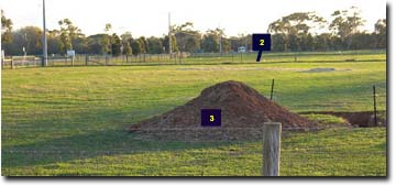
Location: Werribee - Research Farm
Aust. Soil Class.: Hypocalcic, Subnatric, Red SODOSOL (medium to thick surface horizons)
Northcote Factual Key: Dr 2.13
Great Soil Group: red-brown earth
Previous Soil Type (Skene 1954): Deutgam fine sandy clay loam
Maher and Martin (1979) map unit: 9
General Landscape Description: Level plain (with prior streams).
Site Description: Grazing paddock - opposite Dairy Food Training Centre.
Geology: Quaternary alluvial (prior stream) and aeolian deposits.
 WP3 Landscape |
Soil Profile Morphology
Surface Soil | 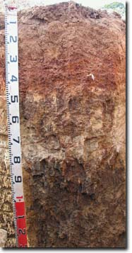 PPW6 Profile | ||
A1 | 0-12 cm | Brown (7.5YR4/4); fine sandy clay loam; pH 5.7; clear change to: | |
A2 | 12-20 cm | Strong brown (7.5YR4/6); heavy fine sandy clay loam; some mixing of B21 horizon material; pH 6.9; clear change to: | |
Subsoil | |||
B21 | 20-45 cm | Dark red (2.5YR4/6); medium clay; strong coarse-medium blocky, parting to strong medium-fine polyhedral structure; pH 7.1: | |
B22 | 45-60 cm | Strong brown (7.5YR5/6) and reddish yellow (7.5YR6/6); light clay; manganese staining; pH 7.3: | |
2A | 60-80 cm | Very pale brown (10YR7/4) with yellowish red (5YR4/6) infill associated with root channels; massive (with macropores); fine sandy clay loam; pH 8.6: | |
2B21 | 80-110 cm | Brown (7.5YR5/4) with strong brown (7.5YR5/6) mottles; medium clay; strong very coarse prismatic, parting to strong coarse-medium angular blocky structure; very few (2%) fine-earth carbonates; some dark manganese staining; pH 8.6: | |
2B22 | 110-140 cm | Greyish brown (2.5Y5/2) with strong brown (7.5YR5/6) mottles; medium clay; strong very coarse prismatic, parting to strong coarse-medium angular blocky structure; pH 8.6. | |
Key Profile Features
- Strong texture contrast between surface (A) horizons and subsoil (B21) horizon.
- Buried soil horizons (of older soils) present.
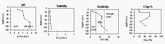
Soil Profile Characteristics
pH | Salinity Rating | |||
Surface (A1 horizon) | Moderately Acid | Low | Non-Sodic | None |
Subsoil (B21 horizon) | Slightly Alkaline | Low | Sodic | None1 |
Deeper subsoil (at 110-140 cm) | Strongly Alkaline | Low-Medium | Strongly Sodic | Strong |
| 1 Strong dispersion after remoulding | ||||
 |
Horizon | Horizon Depth (cm) | pH (water) | pH CaCl2 | EC dS/m | NaCl % | Exchangeable Cations | Ex Al mg/kg | Ex Ac meq/100g | Field pF2.5 | Wilting Point pF4.2 | Coarse Sand (0.2-2.0mm) | Fine Sand (0.02-0.2mm) | Silt (0.002-0.02mm) | Clay (<0.002mm) | |||
Ca | Mg | K | Na | ||||||||||||||
meq/100g | |||||||||||||||||
A1 | 0-12 | 5.7 | 5.3 | 0.19 | 4.3 | 3.1 | 0.63 | 0.37 | <10 | 7.3 | 9 | 38 | 24 | 18 | |||
A2 | 12-20 | 6.9 | 6.5 | 0.13 | 3.7 | 3.0 | 0.18 | 0.64 | 3.9 | 6 | 40 | 28 | 21 | ||||
B21 | 20-45 | 7.1 | 6.4 | 0.16 | 4.9 | 6.6 | 0.47 | 1.6 | 8.3 | 3 | 21 | 17 | 57 | ||||
B22 | 45-60 | 7.3 | 6.6 | 0.17 | 4.4 | 6.8 | 0.60 | 1.6 | 5.4 | 6 | 24 | 19 | 47 | ||||
2A | 60-80 | 8.6 | 8.2 | 0.22 | 6.7 | 4.0 | 0.35 | 1.1 | 7 | 39 | 26 | 23 | |||||
2B21 | 80-110 | 8.6 | 7.9 | 0.32 | 0.04 | 5.5 | 11 | 1.0 | 2.7 | 5 | 29 | 21 | 42 | ||||
2B22 | 110-140 | 8.6 | 7.8 | 0.31 | 0.04 | 4.6 | 14 | 1.4 | 4.3 | ||||||||
<2µm Clay Mineralogy | |||||||
Horizon | Depth cm | Quartz | Mica/Illite | Kaolin | Goethite | Orthclase | Smectite |
B21 | 20-45 | 2 | 39 | 57 | 3 | <1 | - |
2B22 | 110-140 | 6 | 24 | 21 | - | <1 | 47 |
2µm Cation Exchange Capacity | ||||||||||||
Horizon | Depth cm | SiO2 % | Al2O3 % | MgO % | P2O5 % | K2O % | TiO2 % | MnO % | Fe2O3 % | BaO % | Sum % | CEC cmol/kg |
B21 | 20-45 | 42.4 | 26.5 | 1.1 | 0.5 | 2.9 | 1.0 | 0.0 | 10.9 | 1.9 | 87.2 | 26 |
2B22 | 110-140 | 50.6 | 22.0 | 1.5 | 0.2 | 2.4 | 1.1 | 0.0 | 9.7 | 3.9 | 91.5 | 51 |
Management Considerations:
Whole Profile
- Management strategies for all soils should aim to increase organic matter levels in the surface soil; minimise the degradation of soil aggregates and porosity; promote the development o stable biopores; improve the calcium status of the cation exchange complex (particularly when sodium is a significant part), and break up any hardpans. Less frequent tillage; using less aggressive implements, and working the soil at optimum moisture content can all assist in maintaining soil aggregation and porosity as well as reducing the breakdown of organic matter.
- The surface horizons have high fine sand contents which makes them prone to becoming hardsetting and will result in the soil becoming ‘powdery’ when cultivated dry. Increasing organic matter levels will assist in improving surface soil aggregation and ameliorating the hardsetting condition. Organic matter levels will decline under cropping, but can be improved by adopting practices such as minimum tillage, residue retention, and utilising pasture rotations.
- The upper subsoil is sodic (and disperses after remoulding). This is likely to restrict water movement into the subsoil. The subsoil is, however, relatively well structured for a Sodosol, in that it parts to a strong grade of medium to fine sized polyhedral shaped peds. This would provide a more favourable structure for root movement in the upper subsoil compared to other Sodosols.
- The subsoil disperses strongly after remoulding. Care should be taken not to disturb the subsoil (e.g. by tillage) when in a moist to wet condition as structural degradation is likely to occur.
- The deeper subsoil (from 80 cm depth) becomes more coarsely structured. It is also strongly sodic and dispersive. This indicates that root and water movement will be significantly restricted here in the deeper subsoil. Deep drainage will be significantly restricted as a result.
Soil profile described by Mark Imhof and Siggy Engleitner (30 April, 2004).