Victorian Resources Online (archived)
Present Distribution of Noogoora burr (Xanthium strumarium) in Victoria (Nox)
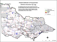 Present Distribution of Noogoora burr | The infestations shown on these maps are derived from the Flora Information Systems (FIS) (2002) and Noxious Weed Survey (Lane et al, 1980). The map is not meant to display a complete statewide inventory for this species. There are areas, for instance, where this species may be present but has not been recorded. IPMS data (managed by DEPI), for example, reflects the regional policies, priorities, programs and available human resources etc over the last 12 or so years (up to early 2003). It is reasonable, therefore, to assume that for most species, the extent of infestations in a region will be greater than is recorded. | |
Information from Noxious Weeds Survey (Lane et al 1980)
| Colour | Infestation | Area (ha) |
| Dark Brown | Dense Infestaion | 2,000 |
| Fawn | Medium | 9,000 |
| Green | Scattered | 28,000 |
| Total | 39,000 |