Victorian Resources Online (archived)
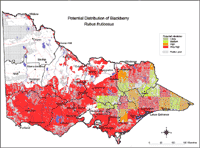
Potential Distribution of Blackberry (Rubus spp.) in Victoria (Nox)
| This map of the potential distribution of Blackberries has been produced from CLIMATE modelling overlayed with: Land Use: Pasture irrigated, Pasture dryland, Forestry (private & public) and Horticulture. Rainfall: Rainfall greater than 550 mm. | |
| Broad Vegetation Types: Dry foothill forests; moist foothill & montane moist forests; grasslands; plains grassy woodlands; valley grassy forests; herb-rich woodlands; montane grassy & riverine grassy woodlands; riparian forests; rainshadow woodlands; lowland forest; swamp scrub; inland slopes and sedge-rich woodlands. Colours indicate the possibility of Rubus spp. infesting these areas. In the non-coloured areas the plant is unlikely to establish as the climate, soil or landuse is not currently suitable. Further information on mapping potential distribution of weeds | |