Victorian Resources Online (archived)
Potential Distribution of Delta arrowhead (Sagittaria platyphylla) in Victoria
| This map of the potential distribution of Delta arrowhead has been produced from CLIMATE® modelling overlayed with: Overlays used Land use: Pasture irrigated and dryland Horticulture Broadacre cropping Broad vegetation types: Riverine grassy woodland; riparian forest; swamp scrub. Colours indicate possibility of Saigttaria platyphylla infesting these areas. Red = Very High Orange = High Light Green = Medium Dark Green = Likely | 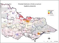 Potential Distribution of Delta arrowhead |
| In the non-coloured areas the plant is unlikely to establish as the climate, soil or landuse is not presently suitable. Further information on mapping potential distribution of weeds | |