Victorian Resources Online (archived)
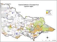
Potential distribution of European privet (Ligustrum vulgare) in Victoria.
| This map of the potential distribution of European privet was produced from CLIMATE® modelling, overlayed with: Overlays used Land Uses: Forestry public and private Broad vegetation types: Dry foothill forests; grasslands; plains grassy woodlands; valley grassy forests; coastal grassy woodland; riverine grassy woodlands; riparian forests; lowland forest; and inland slopes. | |
Colours indicate possibility of Ligustrum vulgare infesting these areas. Red = Very High Orange = High Light Green = Medium Dark Green = Likely In the non-coloured areas the plant is unlikely to establish as the climate, soil or landuse is not presently suitable. Further information on mapping potential distribution of weeds | |