Victorian Resources Online (archived)
Potential Distribution of Ragwort (Senecio jacobaea) in Victoria (Nox)
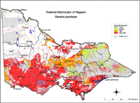
| This map of the potential distribution of Ragwort has been produced from CLIMATE® modelling overlayed with: Overlays used Land use: Pasture irrigated and dryland Rainfall: Rainfall greater than 600 mm Broad vegetation types: Coastal scrubs and grasslands; moist foothill forests, montane moist forests; valley grassy forests; coastal grassy woodlands; riverine grassy woodlands; riparian forests. Colours indicate possibility of Senecio jacobaea infesting these areas. Red = Very High Orange = High Light Green = Medium Dark Green = Likely | |
| In the non-coloured areas the plant is unlikely to establish as the climate, soil or landuse is not presently suitable. Further information on mapping potential distribution of weeds | |