Victorian Resources Online (archived)
Potential Distribution of Spartina (Spartina anglica and S. x townsendii) in Victoria
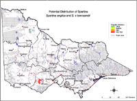
| This map of the potential distribution of Spartina has produced from CLIMATE® modelling, overlayed with: Overlays used Wetland 1994: Permanent saline - Salt works Semisaline - Intertidal flats Hypersaline lakes - Salt flats Mangroves - Salt pan Salt meadows - Sea rush | |
Colours indicate possibility of Spartina spp infesting these areas. Red = Very High Orange = High Light Green = Medium Dark Green = Likely In the non-coloured areas the plant is unlikely to establish as the climate, soil or landuse is not presently suitable. Further information on mapping potential distribution of weeds | |