Victorian Resources Online (archived)
Archived content — This page contains material from the Victorian Resources Online (VRO) website. It is no longer maintained and is provided for reference only. This content is hosted by CeRDI and is not endorsed by Agriculture Victoria.
Sitemap
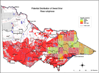
Potential Distribution of Sweet briar (Rosa rubiginosa) in Victoria (Nox)
|
This map of the potential distribution of Sweet briar has produced from CLIMATE® modelling, overlayed with:
Overlays used
Land uses:
Pasture irrigated and dryland
Rainfall:
Rainfall greater than 550 mm
Broad vegetation types:
Dry and moist foothill forests; montane dry woodland; sub-alpine woodland; grasslands; plains grassy woodlands; valley grassy forests; sub-alpine and montane grassy woodland; riverine grassy woodlands; riparian forests; rainshadow woodlands; lowland forest; heath; box ironbark forest; and inland slopes. | |
Colours indicate possibility of Rosa rubiginosa infesting these areas.
Red = Very High
Orange = High
Light Green = Medium
Dark Green = Likely
In the non-coloured areas the plant is unlikely to establish as the climate, soil or landuse is not presently suitable.
Further information on mapping potential distribution of weeds | |