Victorian Resources Online (archived)
Potential Distribution of Oxylobium (Oxylobium lanceolatum) in Victoria
| This map of the potential distribution of Oxylobium was produced from CLIMATE® modelling, overlayed with: Overlays used Land Uses: Pasture irrigated and dryland Rainfall: Annual rainfall greater than 725 mm Broad vegetation types: Moist foothill forests, Montane moist forests, subalpine woodland, subalpine grassy woodlands, riverine grassy woodlands, riparian vegetation, swamp scrub and heathy woodlands.m | 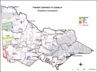 Potential Distribution of Oxylobium |
Colours indicate possibility of Oxylobium lanceolatum infesting these areas. Red = Very High Orange = High Light Green = Medium Dark Green = Likely In the non-coloured areas the plant is unlikely to establish as the climate, soil or landuse is not presently suitable. Further information on mapping potential distribution of weeds | |