Victorian Resources Online (archived)
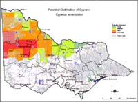
Potential Distribution of Cyperus (Cyperus teneristolon) in Victoria
| This map of the potential distribution of Cyperus has been produced from CLIMATE® modelling overlayed with: Overlays used Land use: Broadacre cropping Horticulture Pasture irrigation Broad vegetation types: Heath; Swamp scrub; Moist foothill forest; Montane moist forest; Sub-alpine woodland; Riparian forest; Mallee; Mallee heath Colours indicate possibility of Cyperus teneristolon infesting these areas. Red = Very high Yellow = High Orange = Medium Green = Likely In the non-coloured areas the plant is unlikely to establish as the climate, soil or landuse is not presently suitable. | |
Further information on mapping potential distribution of weeds | |