Victorian Resources Online (archived)
SFS 17
Location: Woorndoo, Streatham Road South
Aust. Soil Class.: Vertic, Mottled-Hypernatric, Black and Grey SODOSOL
General Landscape Description: Gently undulating plain (relatively elevated plain ~1% and ~70-100 m below crest)
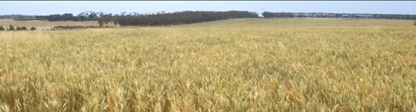
Site Description: Wheat crop.
Geology: Quaternary - Newer Volcanics
 SFS 17 |
Soil Profile Morphology:
| Surface Soil | 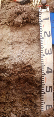 SFS 17 | ||
| Ap | 0-10 cm | Brown (10YR 5/3 moist), light greyish brown (10YR 6/2 dry); fine sandy clay loam; apedal to weakly pedal; abrupt change to: | |
| A21e | 10-20 cm | Light greyish brown (10YR 6/2 moist), conspicuously bleached (10YR 7/3 dry); fine sandy loam; apedal but with platy pan in upper part of horizon; weak to firm consistence; clear change to: | |
| A22c | 20-35 cm | Light greyish brown (10YR 6/2 moist); conspicuously bleached (10YR 7/3 dry); gravelly loam (>70%) (3-20 mm) buckshot; (the coarser buckshot fraction is comprised of cemented smaller buckshot, the finer fraction is magnetic); sharp change to: | |
| Subsoil | |||
| B21t | 35-50 cm | Dark to very dark grey (10YR 4/1 – 3/1) with fine strong red mottles (sometimes yellower and becoming dull yellow with depth); heavy clay; strongly pedal, medium prismatic (25-40 mm) parting to medium blocky (20 mm) structure; strong consistence (dry). | |
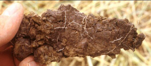 Subsoil ped | 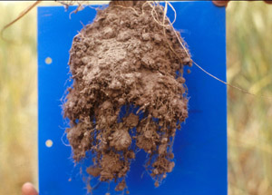 Crop root development |
Key Profile Features:
- Strong texture contrast between surface (A) horizons and subsoil (B21) horizon.
- Conspicuously bleached subsurface (A2) horizon.
Soil Profile Characteristics:
pH | Salinity Rating | |||
Surface (A1 horizon) | Moderately Acid | Low | Non-Sodic | |
Subsoil (B21 horizon) | Near Neutral | Low | Strongly sodic | Strong-Complete |
Deeper subsoil (at 35-50 cm) | Slightly Alkaline | Low-Medium | Strongly Sodic | Strong |
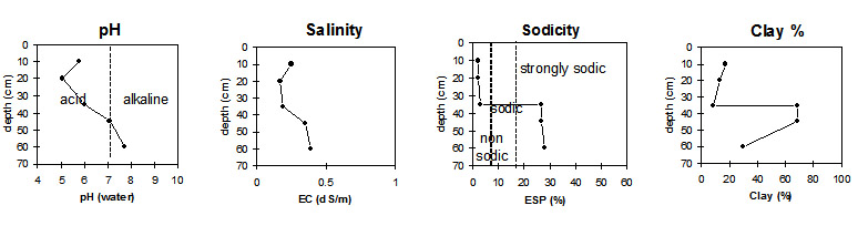 |
Horizon | Horizon Depth (cm) | pH (water) | pH (CaCl2) | EC dS/m | NaCl | Exchangeable Cations | |||
Ca | Mg | K | Na | ||||||
meq/100g | |||||||||
Ap | 0-10 | 5.8 | 5.8 | 0.25 | 6.5 | 1.6 | 0.31 | 0.33 | |
A21 | 10-20 | 5.1 | 4.7 | 0.17 | 1.9 | 0.66 | 0.10 | 0.12 | |
A22 | 20-35 | 6.0 | 5.7 | 0.19 | 1.5 | 0.73 | 0.14 | 0.28 | |
B21 | 35-45 | 7.1 | 6.3 | 0.35 | 0.04 | 5.4 | 9.0 | 0.7 | 5.6 |
B22 | 50-60 | 7.7 | |||||||
Horizon | Horizon Depth (cm) | Exchangeable Aluminium mg/kg | Exchangeable Acidity meq/100g | Field Capacity pF2.5 | Wilting Point pF4.2 | Coarse Sand (0.2-2.0 mm) | Fine Sand (0.02-0.2 mm) | Silt (0.002-0.02 mm) | Clay (<0.002 mm) |
Ap | 0-10 | <10 | 8.8 | 29.2 | 9.8 | 8.0 | 42.6 | 25.5 | 17.0 |
A21 | 10-20 | <10 | 4.6 | 22.4 | 4.4 | 8.4 | 48.9 | 26.5 | 13.5 |
A22 | 20-35 | <10 | 7.4 | 15.8 | 6.5 | 55.2 | 22.4 | 12.5 | 8.5 |
B21 | 35-45 | 41.2 | 26.6 | 6.8 | 13.1 | 7.0 | 68.5 | ||
B22 | 50-60 |
Management Considerations:
Whole Profile
- Plant available water capacity (PAWC) is considered to be low (estimated at 95 mm) in the upper 100 cm of this soil profile.
- Richard Jamieson reports that this paddock has crabhole features with A2 and buckshot of very variable thickness, some places the clay B horizon may be at 60 cm depth while in others the clay is almost at the surface. Generally around 4 metres between crabholes. Soil shows cracking to surface on “clay banks” and crickets are plentiful.
- Profile described by Richard MacEwan, May 1999.