Victorian Resources Online (archived)
SFS 19a
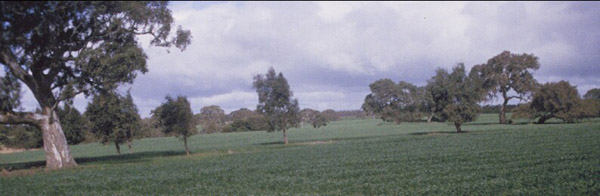
Location: Teesdale-Inverleigh Road
Aust. Soil Class.: Ferric, Subnatric, Brown SODOSOL
General Landscape Description: Level Plain, "top paddock"
Site Description: Level plain, but closer to side of Leigh River Valley
 SFS 19a |
Soil Profile Morphology:
| Surface Soil Ap A2 Subsoil B21 | 0-15/18 cm 10-30 cm | Sandier and more prone to wind erosion: Distinguish A21 and A22; extending to 45 cm depth; minor gravel confined to <10 cm above B21; conspicuously bleached (10YR 7/2 dry); 50-70% gravel 5-20 mm: Wetter subsoil conditions indicated. Coarse units similar to SFS19 but less fractured. Common manganiferous coatings inside peds. | 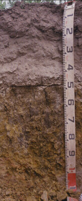 SFS 19a |
Key Profile Features:
| |||
Soil Profile Characteristics:
pH | Salinity Rating | |||
Subsoil (B21 horizon) | Near Neutral | Very Low | Sodic | None1 |
Horizon | Horizon Depth (cm) | pH (water) | pH (CaCl2) | EC dS/m | NaCl | Exchangeable Cations | |||
Ca | Mg | K | Na | ||||||
meq/100g | |||||||||
B21 | 55-65 | 7.1 | 6.5 | 0.24 | 0.08 | 4.3 | 12 | 0.53 | 2.2 |
Horizon | Horizon Depth (cm) | Exchangeable Aluminium mg/kg | Exchangeable Acidity meq/100g | Field Capacity pF2.5 | Wilting Point pF4.2 | Coarse Sand (0.2-2.0 mm) | Fine Sand (0.02-0.2 mm) | Silt (0.002-0.02 mm) | Clay (<0.002 mm) |
B21 | 55-65 | 40.1 | 28.1 | 5.7 | 4.4 | 4.0 | 85.0 |
Notes
- Profile described by Richard MacEwan & Mark Imhof, June, 2000.