Victorian Resources Online (archived)
SFS5b
Location: Brewster, Trawalla East Road (West of Ballarat)
Aust. Soil Class.:Vertic (& Sodic), Eutrophic, Brown CHROMOSOL
Site Description: Level plain with gilgai microrelief (this soil represents the puff component)
Landform: Undulating plain
Element: Simple slope
Slope: 2-5%
Geology: Quaternary - Newer Volcanics
 SFS 5b |
Soil Profile Morphology:
| Surface Soil |  SFS 5b | ||
| Ap | 0 - 20 cm | Brown (10YR4/3 moist) to pale brown (10YR6/3 dry), fine sandy loam to loam, weak to very firm consistence (depending on colour – lighter = stronger); highly variable and mixed material; Ap originally likely to be less than 10 cm and is now dominated by apedal, A2 material. pH 5.5; clear boundary to: | |
| Subsoil | |||
| B21tg | 20 – 70 cm | Mottled light olive brown (2.5Y5/4) and olive yellow (2.5Y6/6); medium clay; irregular medium to coarse (40–80 mm) prismatic parting to medium to coarse (15–40 mm) angular blocky or polyhedral structure; roots between peds contrasts with lack of roots at this depth in the ‘hollow’ component of the gilgai; clear boundary to: | |
| B22gss | 70 + cm | Olive brown (2.5Y4/4 moist) with many (20-50%) light olive brown (10YR5/6) mottles; medium heavy clay; frequent small slickensides; less well developed structure than B21. | |
Key Profile Features:
- Strong texture contrast between surface (A1) horizon and subsoils (B21) horizon.
Soil Profile Characteristics:
pH | Salinity Rating | |||
Surface (A1 horizon) | Strongly Acid | Low | Non-Sodic | None |
Subsoil (B21 horizon) | Slightly Acid | Low | Non-Sodic | None1 |
Deeper subsoil (at 1 m) | Slightly Alkaline | Low | Sodic | None1 |
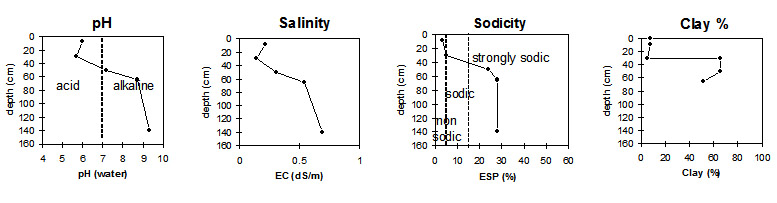 |
Horizon | Horizon Depth (cm) | pH (water) | pH (CaCl2) | EC dS/m | NaCl | Exchangeable Cations | |||
Ca | Mg | K | Na | ||||||
meq/100g | |||||||||
Ap | 0-20 | 5.5 | 5.1 | 0.31 | 0.02 | 4.1 | 0.8 | 0.6 | <0.1 |
B21tg | 20-70 | 6.5 | 5.7 | 0.21 | 6.7 | 12 | 1.5 | 1.6 | |
B21gss | 70+ | 7.5 | 6.6 | 0.3 | 0.03 | 5.1 | 9.7 | 0.7 | 2.4 |
Horizon | Horizon Depth (cm) | Exchangeable Aluminium mg/kg | Exchangeable Acidity meq/100g | Field Capacity pF2.5 | Wilting Point pF4.2 | Coarse Sand (0.2-2.0 mm) | Fine Sand (0.02-0.2 mm) | Silt (0.002-0.02 mm) | Clay (<0.002 mm) |
Ap | 0-20 | <10 | 1 | 33 | 9.1 | 4.1 | 37.7 | 27.5 | 20 |
B21tg | 20-70 | 11 | 51.2 | 28.7 | 0.8 | 10.1 | 7.5 | 78 | |
B21gss | 70+ | 55.3 | 31.1 | 1.1 | 6.2 | 4.5 | 80 |
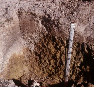
Soil pit at SFS5 showing extremely variable horizon thickness associated with gilgai
Management Considerations:
Whole Profile
- Plant available water capacity (PAWC) is considered to be high (estimated at 160 mm) in the upper 100 cm of this soil profile.
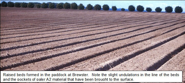
- Described by the owner as ‘crabhole country’, this slightly elevated, gently sloping land has well developed ‘gilgai’ features in the subsoil. The very variable nature of this soil is evident in material in the beds which have white A2 horizon material, buckshot, pisolitic cemented buckshot and subsoil clay all present at the ground surface. ‘Spew’ or ‘hollow units’ are elongated downslope (~10 m). ‘Puffs’ are of smaller lateral dimensions than the ‘hollows’ being 1–3 metres across. In the excavated pit, two faces were picked back. SFS5a to show deep A2 with buckshot and SFS5b to show puff unit (shallow depth to clay).
- This soil presents real problems to the agriculturalist. Water holding properties are extremely different in the ‘puff’ compared with the hollow and this is often evident in the crop. The topsoil is not well structured, disintegrates to a ‘flour’ when dry-tilled, is weak and ‘spewy’ when wet and hard set when dry. Protection of the surface with ground cover is essential to reduce the slaking and sealing effects of rain. Under high rainfall / runoff conditions this soil is potentially highly erodible. The subsoil is sodic and has a high clay content so this soil is also prone to severe waterlogging. The slope of the land and the forming of beds should alleviate this in the surface horizons but erosion is a potential hazard should the furrows carry excessive runoff.
- Second pit opened at crest of hill. Abrupt and steeply inclined boundary between puff and hollow, photographed. Very cemented pisolitic ironstone at base of hollow, >30 cm thickness.
- Soil profile described by Richard MacEwan, May 1999.