Victorian Resources Online (archived)
Archived content — This page contains material from the Victorian Resources Online (VRO) website. It is no longer maintained and is provided for reference only. This content is hosted by CeRDI and is not endorsed by Agriculture Victoria.

Sitemap

Primary Production Landscapes - Geomorphology

Back to: Primary Production Landscapes of Victoria

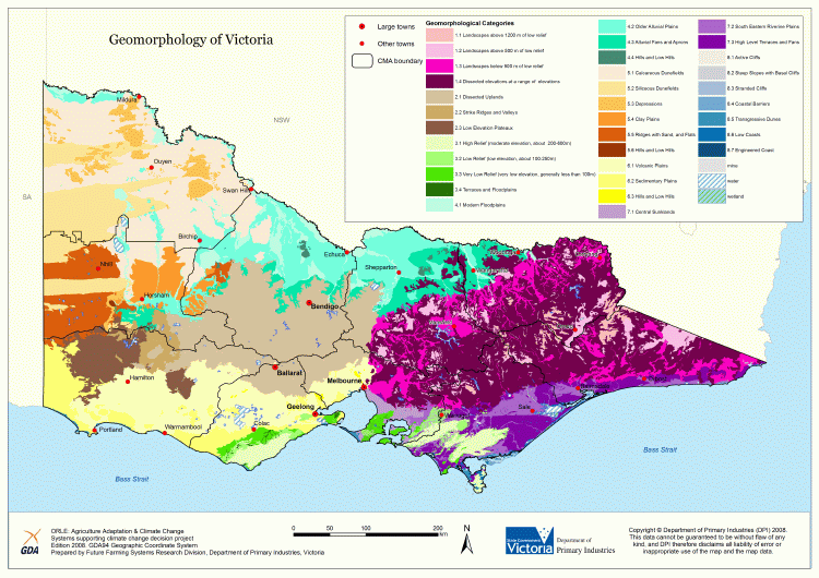
This is a clickable map. Click on Geomorphological framework in Legend for more information.

Primary Production Landscapes of Victoria - Geomorphology

Primary Production Landscapes - Geomorphology
1.1 Landscapes above 1200 m of low relief5.4 Clay plains
1.2 Landscapes above 500 m of low relief5.5 Ridges with sand and flats
1.3 Landscapes below 500 m of low relief5.6 Hills and low hills
1.4 Dissected landscapes at a range of elevations6.1 Volcanic plains
2.1 Dissected uplands6.2 Sedimentary plains
2.2 Strike ridges and valleys6.3 Hills and low hills
2.3 Low elevation plateaux7.1 Central sunklands
3.1 High relief (moderate elevation, about 200-500 m)7.2 South eastern riverine plains
3.2 Low relief (low elevation, about 100-250 m)7.3 High level terraces and fans
3.3 Very low relief (very low elevation, generally less than 100 m)8.1 Active cliffs
4.1 Modern floodplains8.2 Steep slopes with basal cliffs
4.2 Older alluvial plains8.3 Stranded cliffs
4.3 Alluvial fans and aprons8.4 Coastal barriers
4.4 Hills and low hills8.5 Transgressive dunes
5.1 Calcareous dunefields8.6 Low coasts
5.2 Siliceous dunefields8.7 Engineered coast
5.3 Depressions