Victorian Resources Online (archived)
Land Use
| This map is based on general statewide information obtained by satellite image interpretation (1991) and from other statewide datasets. It was initially prepared for State of Environment reporting in 1991 and provides a general indication only, of land use and land tenure across West Gippsland. Data used to generate this map was derived from the land use layer (LANDUSE250) of the Department of Primary Industries Corporate Geospatial Data Library. | 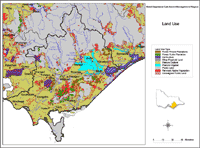 West Gippsland Land Use |
| This map shows the location of State and National Parks in the West Gippsland region, and in nearby regions (as at January 2004). Parks Victoria manages Victoria's world class network of national, state, regional and metropolitan parks, other conservation reserves, many significant cultural assets, and Melbourne's bays and major waterways. The Parks Victoria Parkweb website (external link) provides information about each of Victoria's National and State Parks. |  West Gippsland National State Parks |
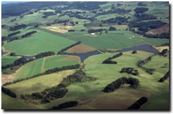
Land use near Thorpdale