Victorian Resources Online (archived)
Archived content — This page contains material from the Victorian Resources Online (VRO) website. It is no longer maintained and is provided for reference only. This content is hosted by CeRDI and is not endorsed by Agriculture Victoria.
Sitemap
23. Doughboy Island
- Sites of Geological and Geomorphological Significance - Site C23 - Doughboy Island
This information has been developed from the publication:
- Sites of Geological and Geomorphological Significance in the South Gippsland Marine and Coastal Parks (1989) Neville Rosengren.
Geological heritage sites, including sites of geomorphological interest and volcanic heritage sites, are under regular revision by the Geological Society of Australia, especially in the assessment of significance and values. Reference should be made to the most recent reports. See the Earth Science Heritage (external link) section of the Geological Society of Australia website for details of geological heritage reports, and a bibliography.
|
| Location | 372080. Southern side of Doughboy Channel 4 km north of Duck Point. |
Access: |
Boat in Doughboy Channel. |
Significant Features: |
This granite island is the northernmost outcrop of the Wilsons Promontory Batholith. It provides and opportunity to obtains samples of material near a margin of the batholith in an area where there is very little outcrop. |
Significance Level: |
Regional. |
Management Issues: |
Not applicable. |
Research & Monitoring Requirements: |
None required. |
Public Interpretation Possibilities: |
No applicable. |
Main References: |
Vertical aerial photographs. |
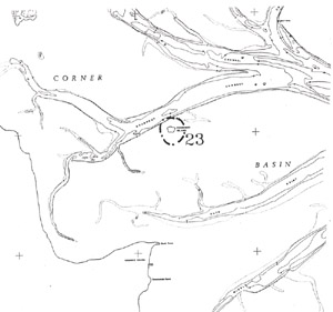
Site 23, Doughboy Island