Victorian Resources Online (archived)
Archived content — This page contains material from the Victorian Resources Online (VRO) website. It is no longer maintained and is provided for reference only. This content is hosted by CeRDI and is not endorsed by Agriculture Victoria.
Sitemap
22. Yarram Formation Quarry
|
This information has been developed from the publications:
- Sites of Geological and Geomorphological Significance in Central Gippsland (1981) by Neville Rosengren, M.S McRae-Williams and S.M Kraemers,
- Sites of Geological and Geomorphological Significance on the Coast of Port Phillip Bay and in the Catchment of Westernport Bay (1984, 88) by Neville Rosengren.
- Sites of Geological and Geomorphological Significance in the South Gippsland Marine and Coastal Parks (1989) by Neville Rosengren.
Geological heritage sites, including sites of geomorphological interest and volcanic heritage sites, are under regular revision by the Geological Society of Australia, especially in the assessment of significance and values. Reference should be made to the most recent reports. See the Earth Science Heritage (external link) section of the Geological Society of Australia website for details of geological heritage reports, and a bibliography. |
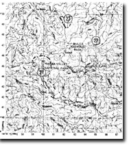
| Location: | 650475. Four kilometres east of Balook. | 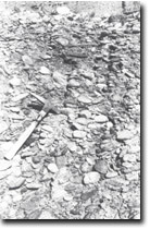
Cemented pebble conglomerate - Blackwarry Road quarry. |
Access: |
Adjacent to Grand Ridge Road. |
Ownership: |
Crown Land. |
Geology/Geomorphology: |
A quarry face exposes pebble beds of the Palaeocene Yarram Formation to a maximum of 20 metres vertically. |
Significance: |
State. The site represents the only complete section exposed within the state of the Yarram formation. |
Management: |
Maintenance of clear exposures within the quarry will maintain the significance of the site. |
Sites 8221-21 22 23