Victorian Resources Online (archived)
Archived content — This page contains material from the Victorian Resources Online (VRO) website. It is no longer maintained and is provided for reference only. This content is hosted by CeRDI and is not endorsed by Agriculture Victoria.
Sitemap
8. Long Swamp
|
This information has been developed from the publications:
- Sites of Geological and Geomorphological Significance in Central Gippsland (1981) by Neville Rosengren, M.S McRae-Williams and S.M Kraemers,
- Sites of Geological and Geomorphological Significance on the Coast of Port Phillip Bay and in the Catchment of Westernport Bay (1984, 88) by Neville Rosengren.
- Sites of Geological and Geomorphological Significance in the South Gippsland Marine and Coastal Parks (1989) by Neville Rosengren.
Geological heritage sites, including sites of geomorphological interest and volcanic heritage sites, are under regular revision by the Geological Society of Australia, especially in the assessment of significance and values. Reference should be made to the most recent reports. See the Earth Science Heritage (external link) section of the Geological Society of Australia website for details of geological heritage reports, and a bibliography. |
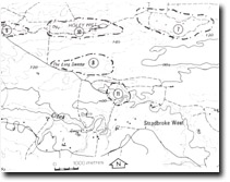
| Location: | 940666. Two kilometres south of Holey Hill. | 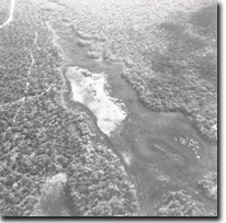
Long Swamp. |
Access: |
Limestone Quarry Road from Rosedale. |
Ownership: |
Crown Land. |
Geology/Geomorphology: |
Long Swamp is an elongated, enclosed drainage system developed on coarse sand and fine gravel of the Haunted Hill Gravels. The swamp is largely covered by a thick sedge growth with only a small area of open water. |
Significance: |
Regional. The Holey Plains are is characterised by internal drainage systems and Long Swamp is a representative example of these wetlands. |
Management: |
The character of the swamp can be rapidly altered by extension of quarrying or land clearing for pine plantation or agriculture in the catchment. Such land disturbance should be prohibited in the swamp catchment. |
Sites 8221 - 7 to 11