Victorian Resources Online (archived)
Archived content — This page contains material from the Victorian Resources Online (VRO) website. It is no longer maintained and is provided for reference only. This content is hosted by CeRDI and is not endorsed by Agriculture Victoria.
Sitemap
11. High Dune Ridges - Gelliondale
|
This information has been developed from the publications:
- Sites of Geological and Geomorphological Significance in Central Gippsland (1981) by Neville Rosengren, M.S McRae-Williams and S.M Kraemers,
- Sites of Geological and Geomorphological Significance on the Coast of Port Phillip Bay and in the Catchment of Westernport Bay (1984, 88) by Neville Rosengren.
- Sites of Geological and Geomorphological Significance in the South Gippsland Marine and Coastal Parks (1989) by Neville Rosengren.
Geological heritage sites, including sites of geomorphological interest and volcanic heritage sites, are under regular revision by the Geological Society of Australia, especially in the assessment of significance and values. Reference should be made to the most recent reports. See the Earth Science Heritage (external link) section of the Geological Society of Australia website for details of geological heritage reports, and a bibliography. |
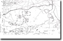
| Location: | 630205. Six kilometres south of Gelliondale. | |
| Access: |
Pearsons Road, off South Gippsland Highway. |
Ownership: |
Crown Land. |
Geology/Geomorphology: |
These are two high dune ridges on the older barriers of the Gelliondale area. |
Significance: |
Local. These are two of the highest dune ridges on the older barrier complex. |
Management: |
Localised land disturbances, such as limited quarrying could be permitted, as there are a number of barrier ridges in the area. |