Victorian Resources Online (archived)
GP85
| Location: near Lake Glenmaggie. | Australian Soil Classification: Bleached-Mottled, Magnesic-Natric, Brown KUROSOL (gravelly) |
| Geology: Tertiary sediments. | General Landscape Description: Gently undulating rise. |
| Soil Mapping Unit: Coongulla. | Site Description: Road cutting adjacent to natural vegetation. |
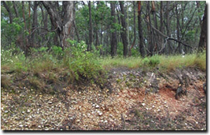 Site GP85 Landscape |
Soil Profile Morphology:
Surface Soil
| A1 | 0-10 cm | Dark greyish brown (10YR4/2); loamy sand; quartz gravel; pH 4.7: | 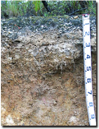 Site GP85 Profile |
| A2 | 10-30 cm | Light yellowish brown (10YR6/4) conspicuously bleached (10YR8/2 dry); loamy sand; quartz gravel common (5-50 mm in size); pH 4.7: | |
| Subsoil | |||
| B21 | 30-50 cm | Yellowish brown (10YR5/4) with yellowish red (5YR5/6), yellow (10YR7/8) and red (2.5YR5/8) mottles; medium clay; strong very coarse prismatic, parting to strong very coarse to strong coarse blocky structure; quartz gravel (2-10 mm); pH 4.8: | |
| B22 | 50-90 cm | Yellowish brown (10YR5/6) with dark red (2.5YR4/6) mottles (30%); light clay; pH 5.1. | |
Key Profile Features:
- Strong texture contrast between sandy surface (A) horizons and clayey subsoil (B21) horizon.
Soil Profile Characteristics:
Horizon | pH | Salinity Rating | ||
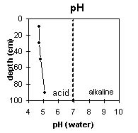
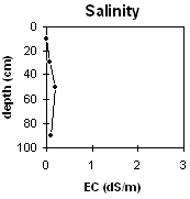
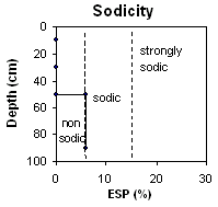
Surface (A1 horizon) | Very Strongly Acid | Very Low | Non-Sodic | None |
Subsoil (B21 horizon) | Very Strongly Acid | Very Low | Marginally Sodic | None1 |
Deeper subsoil (at 50-90 cm) | Strongly Acid | Very Low | Marginally Sodic | None |
 |  |
 |  |
Horizon | Horizon Depth (cm) | pH (water) | pH (CaCl2) | EC 1:5 | NaCl | Exchangeable Cations | |||
Ca | Mg | K | Na | ||||||
meq/100g | |||||||||
A1 | 0-10 | 4.7 | 4.0 | <0.05 | 0.35 | 0.21 | 0.37 | 0.08 | |
A2 | 10-30 | 4.7 | 4.3 | 0.08 | 0.12 | 0.41 | 0.17 | 0.16 | |
B21 | 30-50 | 4.8 | 4.2 | 0.19 | 0.06 | 4.4 | 0.43 | 0.88 | |
B22 | 50-90 | 5.1 | 4.4 | 0.10 | <0.05 | 4.8 | 0.18 | 0.66 | |
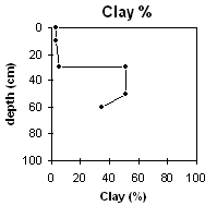
Horizon | Horizon Depth (cm) | Exchangeable Aluminium mg/kg | Exchangeable Acidity meq/100g | Field Capacity pF2.5 | Wilting Point pF4.2 | Coarse Sand (0.2-2.0 mm) | Fine Sand (0.02-0.2 mm) | Silt (0.002-0.02 mm) | Clay (<0.002 mm) |
A1 | 0-10 | 44 | 8.3 | 33 | 47 | 11 | 4 | ||
A2 | 10-30 | 42 | 2.8 | 32 | 46 | 12 | 6 | ||
B21 | 30-50 | 230 | 10 | 21 | 22 | 5 | 51 | ||
B22 | 50-90 | 87 | 5.6 | 32 | 26 | 5 | 35 |
Management Considerations:
Whole Profile
- The soil profile has large amounts of quartz fragments throughout.
- The sandy and strongly leached surface horizons have a very low inherent fertility.
- The coarsely structured (and marginally sodic) subsoil may restrict root and water movement to some degree.
- The subsoil has very low levels of exchangeable calcium compared to exchangeable magnesium (i.e. magnesic). This indicates that nutrient imbalances (e.g. calcium deficiency) may occur.
- The very strongly acid upper subsoil has a high level of exchangeable aluminium – that may restrict the growth of aluminium-sensitive species.