Victorian Resources Online (archived)
Regional Soil/Landform Mapping
Status of Soil/Landform Mapping
A survey of the soils and landforms covering non-public lands throughout the region is currently being completed at 1:100 000 scale and is now being entered onto this website. A number of preliminary reports have been published as part of this survey – including ‘Major Agricultural Soils of the Maffra Region’ (Sargeant and Imhof, 2000). The information provided here can be referenced as: Sargeant, I and Imhof, M. Major Agricultural Soils of West Gippsland - as published on the Victorian Resources Online website.
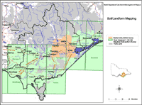 West Gippsland Detailed Soil / Landform Surveys | Mapsheets - (shaded green on map) Foster Mapsheet Moe Mapsheet Sale Mapsheet Stratford Mapsheet Traralgon Mapsheet Warragul Mapsheet Wonthaggi Mapsheet Woolamai Mapsheet Yarram Mapsheet Soils of the Maffra Region - (shaded orange on map) Regional Soil/Landform Mapping Units References |
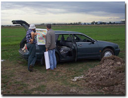 Ian Sargeant discussing soil mapping with a landholder near Sale. |
Access to spatial data
A spatial dataset of Land units of the Gippsland region of Victoria (external link) (DOI 10.4226/92/58e719aeb6e7c) is freely available through the DataVic website.