Victorian Resources Online (archived)
GP16
| Location: Yinnar. | Australian Soil Classification: Mottled, Epipedal, Black VERTOSOL. |
| Northcote Factual Key: Ug 5.1 | Great Soil Group: dark clay |
| Geology: Pleistocene alluvial terrace (old flood plain with prior stream deposits). | General Landscape Description: Far flood plain of old alluvial plain with prior stream activity. |
| Mapping Unit: Yinnar Note: The soil type shown below is only a minor component of the Yinnar mapping unit. |
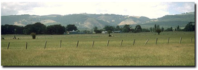 Site GP16 Landscape |
Soil Profile Morphology:
Surface Soil
| A1 | 0-20 cm | Dark greyish brown (10YR4/2); light clay; rusty root channel mottling present; surface cracking when dry; moderate very coarse prismatic, parting to moderate coarse blocky structure; strong consistence dry; contains very few (5%) quartz gravel in patches (5 mm av. size); pH 5.7; clear change to: | 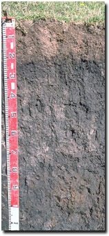 Soil Site GP16 Profile |
| Subsoil | |||
| B21 | 20-50 cm | Very dark grey (10YR3/1); medium clay; weak very coarse prismatic, parting to moderate coarse blocky and strong medium to fine blocky structure; strong consistence dry; pH 5.9; gradual change to: | |
| B22 | 50-80 cm | Very dark grey (10YR3/1); medium clay; weak coarse prismatic, parting to moderate coarse blocky structure; strong consistence dry; pH 6.0; gradual change to: | |
| B23 | 80-105 cm | Dark grey (10YR4/1) with yellowish brown (10YR5/8) mottles; medium heavy clay; weak coarse prismatic, parting to finer prismatic structure; slickensides present; pH 6.0; clear change to: | |
| B3 | 105 cm+ | Very dark grey (10YR3/1); medium heavy clay; strong fine lenticular, parting to strong very fine lenticular structure; slickensides present; pH 5.5. | |
Key Profile Features:
- Clay texture throughout soil profile.
- Shrink-swell (i.e. vertic) properties which result in strong cracking when dry.
Soil Profile Characteristics:
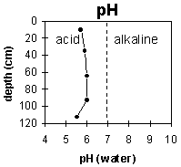 |  | 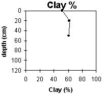 |
| The upper metre of the profile is moderate acid. The deep subsoil becomes strongly acid. | The upper soil profile is non-sodic. The deeper horizons (from 80 cm) depth become sodic. | The clay percentage is high throughout the profile and increases gradually with depth. |
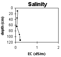
Horizon | Horizon Depth (cm) | pH water | pH CaCl2 | EC 1:5 | Exchangeable Cations | Exch. Al mg/kg | Exch. Acidity meq/100g | Field Capacity pF 2.5 | Wilting Point pF 4.2 | Coarse Sand (0.2 -2.0 mm) | Fine Sand (0.02-0.2 mm) | Silt (0.002-0.02 mm) | Clay (<0.002 mm) | |||
Ca | Mg | K | Na | |||||||||||||
meq/100 g | ||||||||||||||||
A1 | 0-20 | 5.1 | 5.7 | 0.09 | 8.1 | 4.5 | 0.44 | 0.25 | 37 | 20.1 | 2 | 14 | 30 | 52 | ||
B21 | 20-50 | 5.1 | 5.9 | 0.08 | 10 | 6.7 | 0.68 | 0.57 | 40.6 | 24.2 | 0 | 6 | 29 | 62 | ||
B22 | 50-80 | 4.9 | 6 | 0.07 | 9.4 | 6.6 | 0.41 | 0.83 | 37.9 | 22.6 | 1 | 6 | 30 | 62 | ||
B23 | 80-105 | 5.5 | 6 | 0.19 | 12 | 8.1 | 0.48 | 1.4 | ||||||||
B24 | 105-120 | 4.8 | 5.5 | 0.22 | 10 | 8.5 | 0.51 | 1.7 | 34 | |||||||
Management Considerations:
Whole Profile
- Deep cracking occurs when the soil is dry. This will allow heavy rains to move down to the subsoil. When wet, the soil will swell and further infiltration will be relatively slow. Waterlogging can occur in winter as a result.
- Plant available water capacity (PAWC) is considered to be medium (estimated at 135 mm) for the top metre of the soil profile. This is based on available laboratory data. Effective rooting depth is likely to be restricted by the coarsely structured subsoil.
- Tillage or overstocking of clay soils should be avoided if the soil is wet (i.e. wetter than the plastic limit). At such moisture conditions, tillage or over-stocking could result in structural damage (e.g. compaction, smearing) occurring. Ideally, tillage and trafficking should take place when the soil is drier than the plastic limit down to at least the depth of tillage.
- The high wilting point value (i.e. 20%) indicates that plants will not be able to utilise light rains falling on relatively dry soil.
- The subsoil has strong vertic properties which indicates that significant shrinking and swelling occurs during wetting-drying cycles. This can disrupt the roots of perennial plants and will have implications for engineering applications (e.g. building foundations and fencelines).
- The inherent fertility (based on the sum of the exchangeable basic cations) is moderate to high.
- Not a bad winter paddock but water does have trouble getting away.