Victorian Resources Online (archived)
GP17
| Location: Hernes Oak. | Australian Soil Classification: Bleached-Acidic, Dystrophic, Yellow DERMOSOL |
| Northcote Factual Key: Gn 4.64 | Great Soil Group: yellow podsolic. |
| Geology: Tertiary sandstone deposits. | General Site Description: Upper slope of a low hill. |
| Soil Mapping Unit: Boolarra. | |
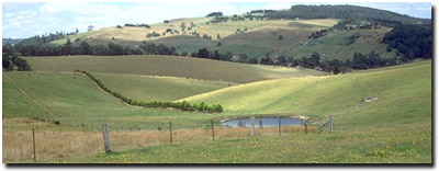 Site GP17 Landscape |
Soil Profile Morphology:
Surface Soil
| A1 | 0-15 cm | Grey (10YR5/1); light sandy loam; weak coarse blocky structure; weak consistence dry; contains a few (2%) quartz crystals (3 mm av. size); pH 4.8; wavy change to: | 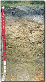 Site GP17 Profile |
| A2 | 15-20 cm | Pale brown (10YR6/3) conspicuously bleached (10YR8/1d); light sandy loam; structureless; variable consistence (weak-strong) dry; pH 4.9; wavy change to: | |
| Subsoil | |||
| B1 | 20-50 cm | Brownish yellow (10YR6/6) with yellowish brown (10YR5/8) mottles; sandy clay loam; weak blocky structure; very firm consistence dry; pH 5.2; gradual change to: | |
| B21 | 50-85 cm | Very pale brown (10YR7/4) with yellowish brown (10YR5/8); fine sandy clay loam (becoming light clay with depth); moderate medium blocky structure; very firm consistence moist; pH 5.3; gradual change to: | |
| B22 | 85-110 cm | Light brownish grey (10YR6/2) with yellowish brown (10YR5/8) mottles; medium clay; moderate coarse blocky, parting to strong fine blocky structure; pH 5.2; clear and wavy change to: | |
| B23 | 110-130 cm | Light grey (10YR7/2) with yellowish brown (10YR5/8) and red (2.5YR4/8) mottles; sandy clay; weak blocky structure weak consistence moist; pH 5.2: | |
| C | 130+ cm | Weathered sandstone. | |
Key Profile Features:
- Moderate texture contrast between surface (A) horizons and upper subsoil (B1) horizon.
- Conspicuously bleached subsurface (A2) horizon (of variable thickness).
Soil Profile Characteristics:
 |  |  |  |
|
|
|
with depth down the soil profile. |
Horizon | Horizon Depth (cm) | pH water | pH CaCl2 | EC 1:5 | Exchangeable Cations | Ex. Al mg/kg | Field Capacity pF 2.5 | Wilting Point pF 4.2 | Coarse Sand (0.2 -2.0mm) | Fine Sand (0.02-0.2mm) | Silt (0.002-0.02mm) | Clay (<0.002 mm) | |||
Ca | Mg | K | Na | ||||||||||||
meq/100 g | |||||||||||||||
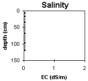
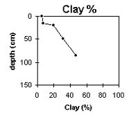
A1 | 0-15 | 4.8 | 3.8 | <0.05 | 1.5 | 0.6 | 0.12 | 0.08 | 150 | 21.5 | 5.9 | 26 | 44 | 20 | 6 |
A2 | 15-20 | 4.9 | 4.0 | <0.05 | 0.41 | 0.15 | <0.05 | <0.05 | 130 | 10.7 | 3.2 | 33 | 43 | 18 | 8 |
B1 | 20-50 | 5.2 | 4.4 | <0.05 | 0.16 | 0.1 | 0.08 | <0.05 | 130 | 19.4 | 8.2 | 19 | 45 | 17 | 20 |
B21 | 50-85 | 5.3 | 4.3 | <0.05 | 0.12 | 1 | <0.05 | 0.06 | 130 | 19.8 | 10.3 | 18 | 39 | 14 | 31 |
B22 | 85-110 | 5.2 | 4.3 | <0.05 | 0.07 | 2.1 | 0.11 | 0.11 | 180 | 25.6 | 15.4 | 14 | 34 | 8 | 47 |
B23 | 110-130 | 5.2 | 4.3 | <0.05 | 0.06 | 1.2 | 0.06 | 0.05 | 110 | ||||||
Management Considerations:
Whole Profile
- Plant available water capacity (PAWC) is considered to be low (estimated at 73 mm) for the top metre of this soil profile. This is based on available laboratory data. Effective rooting depth is probably less than 1 metre as most roots were observed in the top 60 cm of the soil pit profile.
- The nutrient status (based on the sum of the exchangeable basic cations) is very low throughout the profile. This is typical for highly weathered soil profiles.
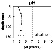
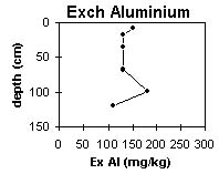
- The surface soil is very strongly acid. This indicates that aluminium and manganese toxicity may occur. The level of exchangeable aluminium measured for this pit site is quite high (150 mg/kg) and likely to restrict the growth of aluminium sensitive species. There should be likely long term benefits of applying lime, preferably incorporated, on this site if the test results are representative of the paddock. A pH/aluminium test is, however, best performed from samples taken across the paddock and bulked together. Other factors need to be considered, however, before lime is recommended (eg. pasture species grown, method of application, local trial responses, soil surface structure and likely cost/benefit).
- Deficiencies of molybdenum, phosphorus and potassium are likely to occur in the very strongly acid surface soil. Increasing soil pH by lime application should enable phosphorus (from superphosphate) and molybdenum to become more available. If lime is required, and pH is increased, then the availability of major nutrients should improve.
- The plant available water holding capacity of the surface soil is low and shallow rooted plants are likely to suffer moisture stress during dry periods. However, the low wilting point value (ie. 6%) indicates that plants will be able to utilise light rains falling on relatively dry soil.
- The inherent fertility (based on the sum of the exchangeable basic cations) of the subsoil is extremely low. These soils have been extensively weathered and many of the nutrients have been leached away.
- In the deeper subsoil, the exchangeable magnesium percentage is high. This is likely to result in nutrient imbalances (eg. calcium and potassium deficiency).
- Exchangeable aluminium levels are still quite high in the strongly acid subsoil.