Victorian Resources Online (archived)
GP18
| Location: Willow Grove. | Australian Soil Classification: Humose-Acidic, Mesotrophic, Grey DERMOSOL (thick clay loamy surface). |
| Northcote Factual Key: Gn 3.01. | Great Soil Group: brown podzolic. |
| Geology: Quaternary alluvial deposits (derived from Baw Baw) overlying Tertiary sandstone. | General Landscape Description: Weakly dissected gently undulating plain. |
| Mapping Unit: Darnum | |
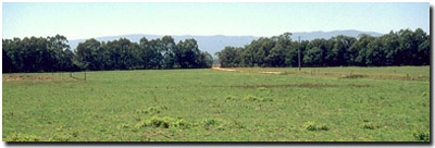 Site GP18 Landscape |
Soil Profile Morphology:
Surface Soil
| A1 | 0-35 cm | Dark greyish brown (10YR4/2); light fine sandy clay loam; moderate coarse blocky structure; weak consistence moist; contains a few (2%) quartz gravels (2-5 mm size); pH 6.6; clear and tongued change to: | 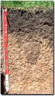 Soil Site GP18 Profile |
| A2 | 35-38 cm | Greyish brown (10YR5/2) sporadically bleached; light fine sandy clay loam; weak blocky structure; weak consistence moist; contains very few (2%) quartz fragments (2-5 mm size); pH 6.3; clear change to: | |
| Subsoil | |||
| B21 | 38-80 cm | Pale brown (10YR6/3) with yellowish brown (10YR5/8) mottles; fine sandy clay loam (becoming light clay with depth); weak coarse blocky structure; weak consistence moist; contains very few (2%) quartz fragments (2-5 mm size); pH 5.3; diffuse change to: | |
| B22 | 80-120 cm | Pale brown (10YR6/3) with yellowish brown (10YR5/8) mottles; light clay; weak consistence moist; moderate coarse blocky, parting to moderate fine blocky structure; contains very few (2%) quartz fragments (2-5 mm size); pH 4.7; clear change to: | |
| B24 | 120 cm+ | Light brownish grey (10YR6/2) with yellowish brown (10YR5/8) mottles; light medium clay; weak consistence moist; contains very few (2%) quartz fragments (2-5 mm size); pH 4.9. | |
Key Profile Features:
- Lack of strong texture contrast between surface (A) and subsoil (B) horizons.
- High level of organic matter in thick surface (A1) horizon (i.e. humose horizon)
Soil Profile Characteristics:
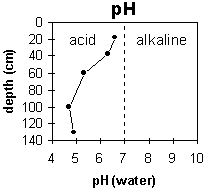 | 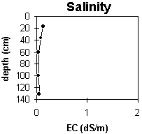 |
The surface soil is slightly acid and the deeper subsoil becomes very strongly acid. | The level of soluble salts is very low throughout the profile. |
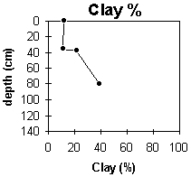 | 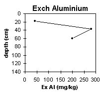 |
The clay content increases gradually with depth down the soil profile. | The Aluminium levels become very high in the deeper subsoil. |
Horizon | Horizon Depth (cm) | pH water | pH CaCl2 | EC 1:5 | Exchangeable Cations | Ex. Al mg/kg | Field Capacity pF 2.5 | Wilting Point pF 4.2 | Coarse Sand (0.2 -2.0 mm) | Fine Sand (0.02-0.2 mm) | Silt (0.002-0.02 mm) | Clay (<0.002 mm) | |||
Ca | Mg | K | Na | ||||||||||||
meq/100 g | |||||||||||||||
A1 | 0-35 | 6.6 | 5.9 | 0.13 | 8 | 1.4 | 0.94 | 0.18 | 27.2 | 10 | 21 | 32 | 32 | 12 | |
A2 | 35-38 | 6.3 | 5.6 | 0.08 | 3.1 | 0.59 | 0.35 | 0.09 | 21.8 | 4.4 | 16 | 10 | 36 | 11 | |
B21 | 38-80 | 5.3 | 4.6 | <0.05 | 1.5 | 0.48 | 0.22 | 0.06 | 42 | 21.1 | 6.9 | 16 | 32 | 34 | 22 |
B22 | 80-120 | 4.7 | 4.1 | <0.05 | .79 | 0.66 | 0.1 | 0.06 | 280 | 27.8 | 13.1 | 10 | 29 | 28 | 39 |
B23 | 120+ | 4.9 | 4.2 | 0.05 | 1.5 | 1.2 | 0.19 | 0.09 | 200 | ||||||
Management Considerations:
- Plant available water capacity (PAWC) is considered to be low (estimated at 65 mm) for the top metre of the soil profile. This is based on available laboratory data. Effective rooting depth may be less than 1 metre as most roots were observed in the top 80 cm of the soil pit profile. Over half (i.e. 36 mm) of the plant available water is in the surface (A1) horizon.
- The surface soil is only slightly acid which reflects the use of lime at this site.
- The inherent nutrient status (based on the sum of the sum of the basic exchangeable cations) is moderate. This also reflects the use of lime and the relatively high organic matter content.
- The inherent nutrient status (based on the sum of the exchangeable basic cations) is very low for the subsoil. This is typical for highly weathered soil profiles.
- Exchangeable aluminium levels become high (i.e. > 200 mg/kg) in the very strongly acid deeper subsoil (from 80 cm depth). This will affect the growth of deeper-rooted aluminium sensitive species.
Comments from Landholder
- Lime applied as well as superphosphate, urea and potash.