Victorian Resources Online (archived)
GP46
| Location: Woodside | Australian Soil Classification: Vertic, Mottled-Subnatric, Grey SODOSOL |
| Geology: Pleistocene alluvial and aeolian deposits. | General Landscape Description: Dune and swale landscape. |
| Soil Mapping Unit: Woodside | Site Description: This site occurs in a swale position within a grazing paddock. |
| Native Vegetation: Original vegetation included Red Stringybark (Eucalyptus macrorhyncha) and Grey Box (E. microcarpa). | |
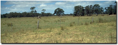 Site GP46 Landscape |
Soil Profile Morphology:
Surface Soil
| A1 | 0-15 cm | Very dark greyish brown (10YR3/2); fine sandy loam; moderate polyhedral, parting to moderate fine polyhedral structure; firm consistence dry; pH 5.6; clear change to: | 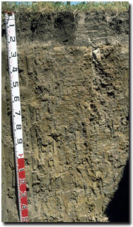 Site GP46 Profile |
| A2 | 15-20 cm | Light brownish grey (10YR6/2), conspicuously bleached (10YR8/1d), with faint dark yellowish brown (10YR4/4) mottles; light fine sandy loam; weak medium prismatic, parting to weak fine prismatic structure; firm consistence dry; contains few (10%) subrounded quartz fragments (2-6 mm in size); pH 5.7; smooth and wavy change varying in depth to: | |
| A3 | 20-30 cm | Light brownish grey (10YR6/2) with dark yellowish brown (10YR4/4 and 10YR4/6) mottles; conspicuously bleached (10YR8/2) material occurs down cracks and on ped faces; light sandy clay loam; weak medium prismatic, parting to weak fine prismatic structure; firm consistence dry; contains a common (15-20%) amount of subrounded quartz fragments (2-6 mm in size); pH 5.6; clear and wavy change to: | |
| Note: Bleach can extend as tongues down into the B21 horizon. | |||
| Subsoil | |||
| B21 | 30-55 cm | Greyish brown (10YR5/2) with yellowish brown (10YR5/8) mottles; medium clay; moderate coarse prismatic, parting to moderate angular blocky structure; strong consistence dry; contains few (5%) sub-rounded quartz fragments (2-5 mm in size); pH 5.6; gradual change to: | |
| B22 | 55-80 cm | Grey (10YR6/1) with yellowish brown (10YR5/6) mottles; medium clay; moderate coarse prismatic, parting to moderate coarse angular blocky, parting to moderate polyhedral structure, as well as some lenticular structure; very sticky consistence wet; contains a common (10-20%) amount of subrounded quartz fragments; pH 5.4; gradual change to: | |
| B23 | 80-150 cm | Grey (10YR6/1) with yellowish brown (10YR5/6) mottles; medium clay; very sticky consistence wet; slickensides present; sub-rounded quartz fragments common (10-20%). | |
Key Profile Features:
- Strong texture contrast between surface (A) and subsoil (B) horizons.
- Conspicuously bleached subsurface (A2) horizon.
pH | Salinity Rating | |||
Surface (A1 horizon) | Moderately Acid | Moderate | Non-Sodic | None |
Subsoil (B21 horizon) | Moderately Acid | Low | Sodic | None1 |
Deeper subsoil (at 80 cm) | Strongly Acid | Low | Sodic | None |
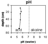 | The surface and upper subsoil is moderately acid, becoming strongly acid at 60 cm depth. | 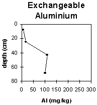 | The levels of exchangeable aluminium are low in the surface horizons and increase in the moderate-strongly acid subsoil. |
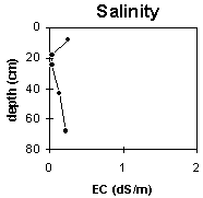 | The salinity rating is moderate in the surface horizon and low throughout the rest of the profile. | 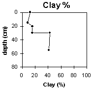 | The clay content increases significantly at the A/B horizon interface. |
Horizon | Horizon Depth (cm) | pH (water) | pH (CaCl2) | EC 1:5 | NaCl | Exchangeable Cations | |||
Ca | Mg | K | Na | ||||||
meq/100g | |||||||||
A1 | 0-15 | 5.6 | 4.9 | 0.25 | <0.03 | 4.7 | 1.9 | 0.18 | 0.37 |
A2 | 15-20 | 5.7 | 4.8 | <0.05 | 1.2 | 0.67 | 0.07 | 0.16 | |
A3 | 20-30 | 5.6 | 4.6 | <0.05 | 0.93 | 1.8 | 0.08 | 0.35 | |
B21 | 30-55 | 5.6 | 4.5 | 0.13 | 1.2 | 6.5 | 0.19 | 1.6 | |
B22 | 55-80 | 5.4 | 4.4 | 0.22 | 0.6 | 5.9 | 0.18 | 2.1 | |
B23 | 80-150 | ||||||||
Horizon | Horizon Depth (cm) | Exchangeable Aluminium mg/kg | Exchangeable Acidity meq/100g | Field Capacity pF2.5 | Wilting Point pF4.2 | Coarse Sand (0.2-2.0 mm) | Fine Sand (0.02-0.2 mm) | Silt (0.002-0.02 mm) | Clay (<0.002 mm) |
A1 | 0-15 | <10 | 11 | 9.3 | 25 | 35 | 24 | 13 | |
A2 | 15-20 | 3.7 | 4.3 | 31 | 38 | 22 | 9 | ||
A3 | 20-30 | 17 | 4.2 | 6.1 | 32 | 35 | 20 | 16 | |
B21 | 30-55 | 110 | 9.8 | 17.2 | 17 | 23 | 16 | 43 | |
B22 | 55-80 | 100 | 8 | 15.4 | 18 | 23 | 19 | 41 | |
B23 | 80-150 |
Management Considerations:
Whole Profile
- Plant available water capacity (PAWC) is considered to be low (estimated at 80 mm) for the top metre of the soil profile. This is based on available laboratory data. However, effective PAWC will be lower than this, as the subsoil is dense and coarsely structured which will restrict root movement. PAWC has been estimated here using a model developed by Littleboy (1995) which uses analytical data for clay %, fine sand %, silt %, coarse sand % and wilting point value.
- The surface (A1) horizon has a low inherent fertility (based on the sum of the exchangeable calcium, magnesium and potassium cations) but has high organic matter, nitrogen and exchangeable calcium levels. Accordingly, it is the most important part of the profile for plant growth. The subsurface (A2 and A3) horizons have a very low inherent fertility.
- All the surface (A1, A2, A3) horizons have a high sand (60-70%) content and infiltration rates will be quite high.
- The presence of a conspicuously bleached (A2) horizon indicates periodic waterlogging occurs above the more slowly permeable subsoil.
- The upper (B21) subsoil has a relatively moderate inherent fertility throughout (based on the sum of the exchangeable basic cations). The subsoil cations are dominated by exchangeable magnesium which may create nutrient imbalances. For example, high levels of exchangeable magnesium may result in potassium deficiencies in some soils (Baker and Eldershaw 1993).
- Within the moderately acid upper (B21) subsoil, exchangeable aluminium levels are reasonably high (110 mg/kg). This may restrict the growth of highly aluminium sensitive species.
- The densely and coarsely structured subsoil (B21) horizon is sodic and has a low exchangeable calcium to magnesium ratio (0.2). Complete dispersion occurs only after remoulding. The relatively high levels of exchangeable aluminium in the subsoil would contribute to reducing dispersion.
- The deeper subsoil displays vertic properties (i.e. slickensides and lenticular structure). This indicates that significant shrinking and swelling occurs during wetting and drying cycles. The presence of bleached material down subsoil cracks also demonstrates this.
- Country only cleared in the 1960’s.
- Hard bore water used for stock only.
- Sheep grazing country.