Victorian Resources Online (archived)
GP50
| Location: Devon. | Australian Soil Classification: Humose-Acidic, Dermosolic, Oxyaquic HYDROSOL |
| Geology: Recent alluvial deposits. | General Landscape Description: Tarra River flats. |
| Soil Mapping Unit: Riverine | Site Description: Grazing paddock. |
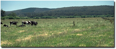 Site GP40 Landscape |
Soil Profile Morphology:
Surface Soil
| A11 | 0-20 cm | Very dark greyish brown (10YR3/2); light silty clay loam; strong fine polyhedral structure; pH 5.0; clear change to: | 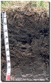 Site GP50 Profile |
| A12 | 20-50 cm | Black (10YR2/1) with faint rusty root channel mottling; light fine sandy clay loam (organic and peaty); moderate polyhedral, parting to strong fine polyhedral structure; pH 4.7; smooth change to: | |
| A2 | 50-90 cm | Very dark grey (10YR3/1) with minor rusty root channel mottling; heavy fine sandy clay loam; pH 5.0; contains organic reed material; water comes into this layer; smooth change to: | |
| Subsoil | |||
| B21 | 90-110 cm | Very dark grey (2.5Y3/1) with minor rusty root channel mottling; fine sandy light clay; weak medium polyhedral structure; minor organic reed content; pH 4.9. | |
Key Profile Features:
- Seasonal saturation (for a number of months each year) of much of the soil profile.
Soil Profile Characteristics:
pH | Salinity Rating | |||
Surface (A1 horizon) | Strongly Acid | Moderate - High | Non-Sodic | None1 |
Subsoil (B21 horizon) | Strongly Acid | Low - Moderate | Non-Sodic | None |
Deeper subsoil (at 1 m) | Very Strongly Acid | Low | Non-Sodic | None |
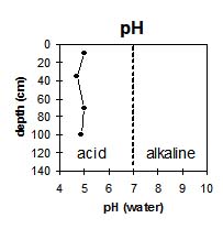 | 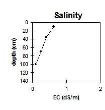 | 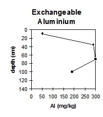 | 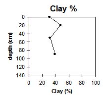 |
The surface soil is strongly acid becoming very strongly acid at 20 cm. | The salinity rating in the surface soil is moderate to high and decreases with depth to relatively low levels. | The levels of exchangeable aluminium are high throughout the sub-soil. | The clay content is fairly constant throughout the profile. |
Horizon | Horizon Depth (cm) | pH (water) | pH (CaCl2) | EC 1:5 | NaCl | Exchangeable Cations | |||
Ca | Mg | K | Na | ||||||
meq/100g | |||||||||
A11 | 0-20 | 5 | 4.6 | 0.63 | 0.07 | 2.8 | 3.1 | 0.4 | 1 |
A12 | 20-50 | 4.7 | 4.3 | 0.4 | 0.05 | 1.2 | 1.6 | 0.3 | 0.7 |
A2 | 50-90 | 5 | 4.9 | 0.24 | 5.8 | 5.3 | 0.34 | 0.81 | |
B21 | 90-110 | 4.9 | 4.3 | 0.1 | 4.6 | 4.1 | 0.31 | 0.48 | |
Horizon | Horizon Depth (cm) | Exchangeable Aluminium mg/kg | Exchangeable Acidity meq/100g | Field Capacity pF2.5 | Wilting Point pF4.2 | Coarse Sand (0.2-2.0 mm) | Fine Sand (0.02-0.2 mm) | Silt (0.002-0.02 mm) | Clay (<0.002 mm) |
A11 | 0-20 | 52 | 25 | 26.8 | 10 | 10 | 31 | 31 | |
A12 | 20-50 | 290 | 29 | 32.5 | 2 | 5 | 25 | 48 | |
A2 | 50-90 | 300 | 31 | 30.6 | 10 | 9 | 30 | 32 | |
B21 | 90-110 | 190 | 19.9 | 1 | 10 | 41 | 39 |
Management Considerations:
Whole Profile
- Plant available water capacity (PAWC) is considered to be moderate (estimated at 110 mm) for the top metre of the soil profile. This is based on available laboratory data. PAWC has been estimated using a model developed by Littleboy (1995) which uses analytical data for clay %, silt %, fine sand %, coarse sand % and wilting point value.
- Much of the soil profile is saturated for prolonged periods (i.e. several months) in most years (i.e. Hydrosol). Subsurface drainage may be a viable management option for such soils.
- The levels of exchangeable aluminium are moderate in the strongly acid surface (A11) horizon (50 mg/kg) but become very high in the very strongly acid subsurface horizons (300 mg/kg) These levels are likely to restrict the growth of aluminium sensitive species e.g. lucerne, phalaris. A pH/aluminium test sampled from across the paddock would be most appropriate to determine whether lime is needed to raise soil pH. Other factors need to be considered before lime is recommended e.g. pasture species grown, method of application, local trial responses, soil surface structure and likely cost/benefit.
- Deficiencies in molybdenum and phosphorus are likely to occur in strongly acid soils. If lime is required, an application may assist in alleviating molybdenum deficiency and will increase phosphorus availability, as well as increasing soil pH. Phosphorus tends to become 'fixed' by high levels of exchangeable aluminium.
- Manganese toxicity may also occur in strongly acid soils, particularly when poorly drained as waterlogging may bring manganese into solution.
- The organic matter levels are very high for the surface (A11 and A12) horizons and extremely high for the subsurface (A2) horizon. Organic matter is important for maintaining aggregation on such soils.
- The surface soil is likely to suffer structural degradation e.g. pugging, compaction, if overstocking occurs whilst the soil is wet.
- The relatively high wilting point value (i.e. 27%) indicates that plants will not be able to utilise light rains falling on relatively dry soil. If the soil dries out, then small falls of rain may not be sufficient to wet the soil above permanent wilting point. The high wilting point also indicates that water is ‘held tightly’ by the soil, decreasing its availability to plants as the water content approaches this point.
- The salinity rating is moderate for the surface (A11) horizon which may restrict the growth of highly salt sensitive species.
- The upper subsoil (B21) horizon has a moderate inherent fertility based on the sum of the basic exchangeable cations.
- Exchangeable aluminium levels remain high throughout the very strongly acid subsoil which has implications for aluminium sensitive species (e.g. lucerne, phalaris).
- Root growth may also be restricted by seasonal saturation of the subsoil.