Victorian Resources Online (archived)
GP51
| Location: Dalyston. | Australian Soil Classification: Eutrophic, Mottled-Subnatric, Black SODOSOL |
| Geology: Cretaceous sediments. | General Landscape Description: Upper mid slope (8%) (easterly aspect) of a rolling hill. |
| Soil Mapping Unit: Koonwarra | |
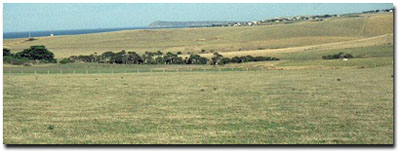 Site GP51 Landscape |
Soil Profile Morphology:
Surface Soil
| A1 | 0-15 cm | Very dark greyish brown (10YR3/2); clay loam fine sandy; moderate coarse subangular blocky, parting to strong fine polyhedral, and fine subangular blocky structure; very firm consistence dry; pH 5.7; clear change to: | 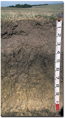 Site GP51 Profile |
| A2 | 15-35 cm | Greyish brown (10YR5/2) conspicuously bleached (10YR7/2d); clay loam fine sandy; root channel mottling present; moderate subangular blocky, parting to weak fine polyhedral structure; very firm to strong consistence dry; contains a few (2%) subrounded manganese (< 5 mm in size) segregations; pH 6.0; clear and wavy change to: | |
| Subsoil | |||
| B21 | 35-55 cm | Very dark greyish brown (10YR3/2) with few (10%) brownish yellow (10YR6/6) mottles; heavy clay; strong coarse prismatic, parting to moderate coarse prismatic, parting to moderate coarse angular polyhedral structure; strong consistence dry; smooth faced peds; pH 6.1; gradual change to: | |
| B22 | 55-85 cm | Light olive brown (2.5Y5/4) with brownish yellow (10YR6/6) and dark greyish brown (10YR4/2) mottles common (10-20%); medium heavy clay; more plastic than clay above; strong coarse prismatic, parting to moderate coarse blocky structure; pH 6.6; gradual change to: | |
| C | 85-100+ cm | Weathered sediments. | |
Key Profile Features:
- Strong texture contrast between surface (A1) horizon and subsoil (B21) horizon.
- A sporadic bleach occurs occasionally within the subsurface (A2) horizon.
Horizon | pH | Salinity Rating | ||
Surface (A1 horizon) | Moderately Acid | Low | Non-Sodic | __ |
Subsoil (B21 horizon) | Slightly Acid | Very Low | Marginally Sodic | None |
Deeper subsoil (at 80 cm) | Slightly Acid | Very Low | Sodic | None |
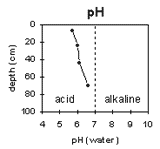 | 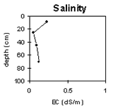 | 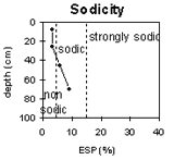 | 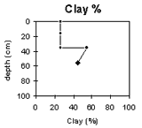 |
The surface soil is moderately acid. The subsoil is slightly acid. | The salinity rating in the surface soil is low becoming very low in the subsoil. | The surface soil is non-sodic. The subsoil is sodic. | The clay percentage increases markedly at the A/B boundary. |
Horizon | Horizon Depth (cm) | pH water | pH CaCl2 | EC 1:5 | Exchangeable Cations | Ex. Al mg/kg | Ex. Acidity meq/100g | Wilting Point pF 4.2 | Coarse Sand (0.2 - 2.0 mm) | Fine Sand (0.02-0.2 mm) | Silt (0.002-0.02 mm) | Clay (<0.002 mm) | |||
Ca | Mg | K | Na | ||||||||||||
meq/100g | |||||||||||||||
A1 | 0-15 | 5.7 | 5.1 | 0.22 | 7.8 | 3.6 | 0.79 | 0.71 | <10 | 14 | 17.7 | 4 | 28 | 32 | 36 |
A2 | 15-35 | 6 | 4.9 | 0.05 | 1.6 | 4.2 | 3.4 | 0.2 | <10 | 11 | 11.4 | 4 | 35 | 31 | 25 |
B21 | 35-55 | 6.1 | 5 | 0.09 | 7.2 | 12 | 0.59 | 1.8 | 16 | 10 | 24.5 | 1 | 22 | 18 | 54 |
B22 | 55-85 | 6.6 | 5.6 | 0.12 | 5.8 | 13 | 0.39 | 2.4 | <10 | 6.5 | 21.4 | 1 | 35 | 19 | 45 |
Management Considerations:
Surface (A) Horizons
- The presence of conspicuous bleaching and root channel mottling in the subsurface (A2) horizon indicates that periodic waterlogging occurs above the more slowly permeable subsoil.
- The upper subsoil is dense and coarsely structured which will result in restricted root and water movement.