Victorian Resources Online (archived)
GP82
| Location: Labertouche. | Australian Soil Classification: Magnesic, Mottled-Hypernatric, Grey SODOSOL. |
| Geology: Quaternary alluvium (late Pleistocene). | General Landscape Description: Level plain (Tynong mapping unit). |
| Site Description: Grazing paddock. | |
Soil Profile Morphology:
Surface Soil
| A1 | 0-15 cm | Black (10YR2/1), light sandy clay loam (organic); weak coarse blocky structure, moist consistence (weak); organic mat to 4 cm; pH 4.8; abrupt and wavy change to: | 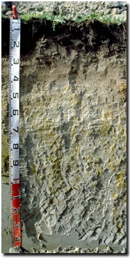 Site GP82 Profile |
| A21 | 15-35 cm | Brown (10YR5/3); sandy loam; weak to firm consistence (moist); pH 4.9; gradual change to: | |
| A22 & Bhs | 35-60 cm | Light grey (10YR7/2) with few yellow (10YR7/6) mottles; light sandy clay loam; weak to firm consistence (moist); pH 7.0; discontinuous "coffee rock" layer; wavy and clear change to: | |
| Subsoil | |||
| B21 | 60-80 cm | Light grey (10YR7/2) and light brownish grey (10YR6/2) with yellow (10YR7/8) and reddish yellow (7.5YR6/8) mottles; medium clay with grit; moderate coarse blocky structure; very firm consistence (moist); quartz fragments common (20%) with some feldspar; pH 7.7; gradual change to: | |
| B22 | 80-120 cm | Light brownish grey (10YR6/2) with reddish yellow (7.5YR6/8) mottles; light medium clay with grit; moderate very coarse blocky, parting to moderate coarse blocky structure; feldspar (10%) 2-5 mm fragments; pH 7.8: | |
| B23 | 120+ cm | Light brownish grey (10YR6/2); light medium clay with grit; pH 7.5. | |
Key Profile Features:
- Strong texture contrast between surface (A) horizons and subsoil (B) horizons.
Soil Profile Characteristics:
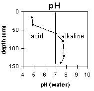
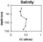
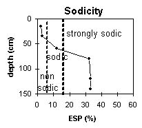
pH | Salinity Rating | |||
Surface (A1 horizon) | Very strongly acid | Medium | Non-sodic | None |
Subsoil (B21 horizon) | Slightly alkaline | Medium - High | Strongly Sodic | None1 |
Deeper Subsoil (at 1.2 m) | Slightly alkaline | Medium - High | Strongly Sodic | None1 |
| 1Complete dispersion after remoulding | ||||
 |  |  |  |
Horizon | Horizon Depth (cm) | pH (water) | pH (CaCl2) | EC 1:5 | NaCl | Exchangeable Cations | |||
Ca | Mg | K | Na | ||||||
meq/100g | |||||||||
A1 | 0-15 | 4.8 | 4.1 | 0.35 | 0.07 | 4.0 | 1.1 | 0.2 | 0.5 |
A21 | 15-35 | 4.9 | 4.5 | 0.31 | 0.07 | 0.6 | 0.2 | <0.1 | <0.1 |
A22 | 35-60 | 7.0 | 6.4 | 0.33 | 0.07 | 0.5 | 0.9 | <0.1 | 0.2 |
B21 | 60-80 | 7.7 | 7.1 | 0.51 | 0.12 | 0.8 | 3.7 | 0.3 | 2.2 |
B22 | 80-120 | 7.8 | 7.1 | 0.48 | 0.11 | 0.6 | 4.4 | 0.2 | 2.5 |
B23 | 120+ | 7.5 | 6.9 | 0.41 | 0.10 | 0.4 | 3.3 | 0.2 | 1.9 |
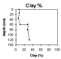
Horizon | Horizon Depth (cm) | Exchangeable Aluminium mg/kg | Exchangeable Acidity meq/100g | Field Capacity pF2.5 | Wilting Point pF4.2 | Coarse Sand (0.2-2.0 mm) | Fine Sand (0.02-0.2 mm) | Silt (0.002-0.02 mm) | Clay (<0.002 mm) |
A1 | 0-15 | 39 | 17 | 31.7 | 10.3 | 31.9 | 29.2 | 19.0 | 8.0 |
A21 | 15-35 | 12 | 2.0 | 15.4 | 2.3 | 37.8 | 32.5 | 21.5 | 6.0 |
A22 | 35-60 | 13.5 | 1.0 | 33.6 | 34.5 | 21.0 | 10.0 | ||
B21 | 60-80 | 21.4 | 10.3 | 30.4 | 23.0 | 17.0 | 28.0 | ||
B22 | 80-120 | 25.8 | 19.5 | 29.0 | 20.4 | 16.5 | 32.0 | ||
B23 | 120+ | 28.3 | 23.2 | 18.0 | 28.0 |
Management Considerations:
Subsoil (B) Horizons
- Very low exchangeable calcium:magnesium ratio (i.e. <0.2). This may result in nutrient imbalances (e.g. calcium deficiency).