Victorian Resources Online (archived)
Powlett (Po)
| Geology Recent alluvium, mostly derived from the Cretaceous hills to the north. Landform Flood plain - an alluvial plain characterised by frequently active erosion and aggradation (i.e. alluvial deposition) by channelled or overbank stream flow. Frequently active means that flow has an average recurrence interval of 50 years or less. |  |
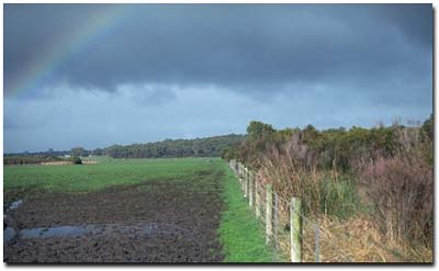
Floodplain landscape near Leongatha South. Note original vegetation at right of photo.
Soils
Most of the soils have very dark grey to black very fine sandy loam to clay loam surface soil which gradually changes to a light brownish grey similarly textured subsoil at about 30 to 50 cm. Parts of the lower part of this horizon are occasionally slightly cemented and grade into light brownish-grey mottled with brownish-yellow fine sandy clay loams to light clays. Similarly coloured medium clays are generally encountered before 1 m depth. Site SG1 is an example of a Hydrosol within this unit.
Occurrence
This mapping unit occurs over most of the Powlett river flats.