Victorian Resources Online (archived)
SG1
|
Location: Leongatha South. | Australian Soil Classification: Humose-Acidic, Dermosolic, Redoxic HYDROSOL |
| Northcote Factual Key: Gn 4.61 | Geology: Quaternary alluvium which has originated from the South Gippsland Uplands. |
| General Landscape Description: Very gently undulating alluvial plain. | Soil Mapping Unit: Powlett. |
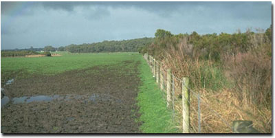
| Site Description: Roadside verge near corner of Hillgroves Road and Hudson Road at Leongatha South. This site is seasonally saturated for an average of 3-5 months per year. | |
| Native Vegetation: Includes Swamp Paperbark (Melaleuca ericifolia), Gippsland Mallee (Eucalyptus kitsoniana), Swamp Gum (E. ovata). | |
 Site SG1 Landscape |
Soil Profile Morphology:
Surface Soil
| A11 | 0-20 cm | Black (10YR2/1); very fine sandy loam; firm surface condition; weak very coarse blocky structure; weak consistence dry; pH 5.2; gradual change to: | 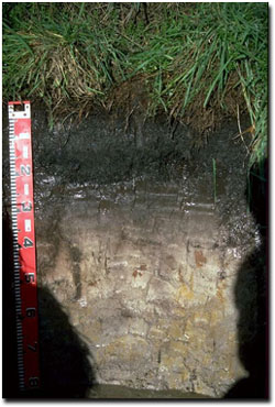 Site SG1 Profile |
| A12 | 20-30 cm | Very dark grey (10YR3/1); very fine sandy loam; firm consistence dry; pH 5.1; gradual change to: | |
| A2 | 30-45 cm | Greyish brown (10YR5/2) conspicuously bleached (10YR7/2d); very fine sandy loam; firm consistence dry; contains a few "coffee rock" (soft to semi hard) fragments at 40-45 cm depth; pH 4.9; gradual change to: | |
| Subsoil | |||
| B21 | 45-70 cm | Light brownish grey (10YR6/2) with brownish yellow (10YR6/6) diffuse mottles; light very fine sandy clay loam; strong consistence dry; moderately structured; pH 4.7; gradual change to: | |
| B22 | 70-80 cm | Light brownish grey (10YR6/2) with brownish yellow (10YR6/8) diffuse mottles; silty clay; moderate structure; pH 4.7. | |
Key Profile Features:
- No clear or abrupt texture change throughout the profile.
- Humus rich surface horizon.
- High fine sand and silt content throughout the profile.
Soil Profile Characteristics:
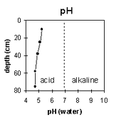 | 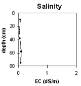 | 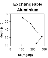 | 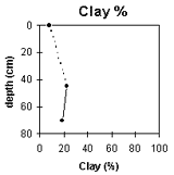 |
The soil is strongly acid in the surface horizon and becomes very strongly acid from 30 cm. | Total soluble salt levels are very low throughout the whole profile. | Exchangeable aluminium levels increase with depth down the profile. | No large increase in clay percentage throughout the profile. |
Horizon | Horizon Depth (cm) | pH (water) | pH (CaCl2) | EC 1:5 | Exchangeable Cations | Exchangeable Aluminium mg/kg | Exchangeable Acidity meq/100g | Wilting Point pF4.2 | Coarse Sand (0.2- 2.0 mm) | Fine Sand (0.02-0.2 mm) | Silt (0.002-0.02 mm) | Clay (<0.002 mm) | |||
Ca | Mg | K | Na | ||||||||||||
meq/100g | |||||||||||||||
A11 | 0-20 | 5.2 | 4.1 | 0.06 | 1.5 | 1.2 | 0.3 | 0.1 | 110 | 14 | 7.3 | 1 | 50 | 34 | 8 |
A12 | 20-30 | 5.1 | 3.8 | <0.05 | 0.4 | 0.4 | 0.1 | 0.1 | 180 | 12.8 | 4.7 | ||||
A2 | 30-45 | 4.9 | 4.0 | 0.05 | 0.2 | 0.3 | 0.2 | <0.1 | 210 | 9.2 | |||||
B21 | 45-70 | 4.7 | 4.0 | 0.09 | 0.2 | 0.3 | 0.2 | <0.1 | 280 | 9.8 | 2 | 46 | 31 | 23 | |
B22 | 70-80 | 4.7 | 4.1 | 0.08 | 0.1 | 0.3 | 0.1 | <0.1 | 230 | 4.8 | 2 | 48 | 34 | 19 | |
Management Considerations:
Whole Profile
- The major limitation with this soil is the poor site drainage - which results in the profile being saturated for prolonged periods (several months or more) in most years.
- This soil has a very low inherent fertility. This is due in part to the very high fine sand (50%) and silt (34%) content which results in a low cation exchange capacity.
- The surface soil has a high organic matter content. This is important for maintaining soil aggregation on surface soils with high fine sand and silt contents. If organic matter levels are low then structural deterioration (e.g. exacerbated hardsetting, compaction and surface sealing) is more likely to occur. The surface soil organic matter is also important in terms of cation exchange.
- The surface soil is strongly acid which indicates that aluminium toxicity may occur. The level of exchangeable aluminium measured in the laboratory (110 mg/kg) is high enough to affect aluminium sensitive species. If the test results are representative of this paddock, then there should be long term benefits of incorporating lime into this soil. Raising surface soil pH will help reduce any toxic effects of aluminium.
- Deficiencies in molybdenum, phosphorus and potassium may occur in the strongly acid surface soil. Lime application may assist in alleviating molybdenum deficiency and will increase phosphorus availability. Plant tissue analysis may give a more accurate assessment of molybdenum deficiency. Phosphorus tends to become "fixed" by high levels of exchangeable aluminium.
- The level of exchangeable aluminium increases in the A12 and A2 horizons to levels which are likely to affect a number of moderately aluminium sensitive plant species (e.g. sub clover, white clover and cocksfoot) and possibly some more tolerant species (e.g. ryegrass, cocksfoot).
- Pugging caused by stock will be a problem in wet seasons.
- The inherent fertility of the subsoil is very low.
- The level of exchangeable aluminium increases in the subsoil to very high levels (i.e. 280 mg/kg). Root development of aluminium sensitive species into this zone is likely to be restricted.