Victorian Resources Online (archived)
SG11
| Location: Fish Creek Landcare Group. | Australian Soil Classification: Vertic, Eutrophic, Brown KUROSOL |
| Northcote Factual Key: Dy 3.41. | Great Soil Group: soloth. |
| Geology: Cretaceous mudstone at a depth of 1.5 metres. | General Landscape Description: Midslope of a low undulating rise (1-2% slope). |
| Soil Mapping Unit: Koonwarra. | General Site Description: On grassed verge of farm track. |
| Native Vegetation: Messmate (Eucalyptus obliqua), Blackwood (A. melanoxylon). | |
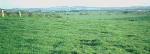 Site SG11 Landscape |
Soil Profile Morphology:
Surface Soil
| A1 | 0-15 cm | Dark greyish brown (10YR4/2); fine sandy clay loam; hardsetting surface condition; strong polyhedral structure; very firm consistence dry; pH 6.3; abrupt and wavy change to: | 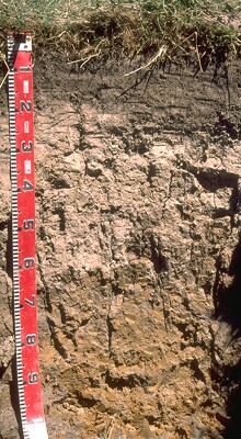 Site SG11 Profile |
| A2 | 15-45 cm | Light brownish grey (10YR6/2) conspicuously bleached (10YR7/2d); fine sandy clay loam; strong consistence dry; rusty root channel mottling present; pH 5.8; clear and wavy change to: | |
| Subsoil | |||
| B21 | 45-70 cm | Brown (10YR5/3) with brownish yellow (10YR6/8) mottles; medium heavy clay; strong coarse prismatic, breaking down to strong coarse blocky structure; very strong consistence dry; pH 5.3; gradual change to: | |
| B22 | 70+ cm | Light brownish grey (10YR6/2) with brownish yellow (10YR6/8) mottles; medium clay; strong coarse prismatic, breaking down to strong coarse blocky structure; firm consistence moist; slickensides present; pH 5.2. | |
| NOTE: In some areas the fine sandy clay loam A2 horizon may be absent and the surface A1 horizon lies directly over the medium heavy clay subsoil. The sample was taken from across paddock. | |||
Key Profile Features:
- Strong texture contrast between the surface (A) and subsoil (B) horizons.
- Evidence of vertic properties in the subsoil.
Soil Profile Characteristics:
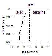 | 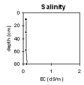 |  | 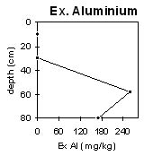 |
The soil profile is mainly strongly acid throughout. The subsurface (A2) horizon here is moderately acid. | Soluble salt levels are very low throughout the profile. | The exchangeable aluminium levels become high in the strongly acid subsoil. | There is an abrupt textural change at the A/B horizon boundary. |
Horizon | Horizon Depth (cm) | pH (water) | pH (CaCl2) | EC 1:5 | Exchangeable Cations | |||
Ca | Mg | K | Na | |||||
meq/100g | ||||||||
A1 | 0-15 | 6.3 | 5.6 | 0.10 | 13 | 2.0 | 0.2 | 0.2 |
A2 | 15-45 | 5.8 | 4.8 | 0.09 | 2.5 | 1.5 | 0.1 | 0.2 |
B21 | 45-70 | 5.3 | 4.3 | 0.10 | 6.3 | 8.2 | 0.4 | 0.6 |
B22 | 70+ | 5.2 | 4.2 | 0.12 | 2.2 | 9.0 | 0.4 | 1.1 |
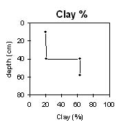
Horizon | Horizon Depth (cm) | Exchange- able Aluminium mg/kg | Exchange- able Acidity meq/100g | Field Capacity pF2.5 | Wilting Point pF4.2 | Coarse Sand (0.2-2.0 mm) | Fine Sand (0.02-0.2 mm) | Silt (0.002-0.02 mm) | Clay (<0.002 mm) |
A1 | 0-15 | <10 | - | 32 | 14 | 9 | 30 | 32 | 20 |
A2 | 15-45 | - | - | 24 | 8 | 9 | 33 | 37 | 21 |
B21 | 45-70 | 260 | 18.0 | 45 | 26 | 4 | 10 | 18 | 63 |
B22 | 70+ | 170 | 22.8 | - | - | - | - | - | - |
Management Considerations:
Whole Profile
- Plant Available Water Capacity (PAWC) is considered to be medium (estimated at approximately 135 mm) for the top metre of the soil profile. Rooting depth may be restricted by the high exchangeable aluminium levels in the coarsely structured subsoil.
- The surface soil is slightly acid (pH 6.3). The level of exchangeable aluminium measured across the paddock is low (<10mg/kg) and may only restrict the growth of highly aluminium sensitive species.
- Exchangeable aluminium values are high at the top of the strongly acid subsoil. At these levels, the growth of aluminium sensitive species may be affected in areas where the subsoil is closer to the soil surface (ie. where no A2 is present). Even more tolerant species such as cereal rye and cocksfoot may also be affected.
- The subsoil displays evidence of slight vertic properties (i.e. some slickensides are present). As a result, the subsoil may be subject to significant swelling and shrinking on wetting and drying. This could explain some of the variability across the pit site (i.e. lack of A2 horizon in some areas). In soils that have strong vertic properties there are implications for engineering purposes (e.g. building foundations).
- Phosphorus and lime have been applied.