Victorian Resources Online (archived)
SG12
| Location: Fish Creek North. | Australian Soil Classification: Acidic, Mesotrophic, Brown DERMOSOL. |
| Northcote Factual Key: Gn 4.31. | Great Soil Group: brown podzolic. |
| Geology: Cretaceous sediments at a depth of 100 cm. | General Landscape Description: Upper slope of steep hills landscape unit (up to 40% slope). |
| Soil Mapping Unit: Strzelecki. | Site Description: Grazing paddock which has never been cropped. |
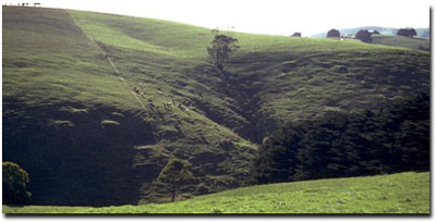 Site SG12 Landscape |
Soil Profile Morphology:
Surface Soil
| A11 | 0-15 cm | Dark greyish brown (10YR4/2); silty clay loam; hardsetting surface condition; moderate blocky structure; firm consistence moist; pH 4.8; abrupt change to: | 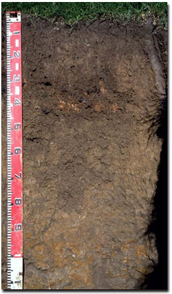 Site SG12 Profile |
| A12 | 15-35 cm | Brown (10YR4/3); heavy silty clay loam; weak blocky structure; firm consistence moist; pH 4.7; clear and wavy change to: | |
| Subsoil | |||
| B21 | 35-60 cm | Yellowish brown (10YR5/4); light clay; moderate medium polyhedral structure; firm consistence moist; pH 4.7; gradual change to: | |
| B22 | 60-80 cm | Pale brown (10YR6/3) with slight strong brown (7.5YR5/6) mottles; light medium clay; moderate polyhedral structure; very firm consistence moist; pH 4.8: | |
| B23 | 80-100 cm | Pale brown (10YR6/3) with slight strong brown (7.5YR5/8) mottles; medium clay; moderate coarse polyhedral structure; strong consistence moist; pH 4.7: | |
| C | 100+ cm | Weathered sedimentary rock. | |
Key Profile Features:
- Lack of strong texture profile between surface (A) horizons and subsoil (B) horizons.
Soil Profile Characteristics:
- High exchangeable aluminium levels occur throughout the profile but are highest in the subsurface (A12) horizon and in the upper subsoil.
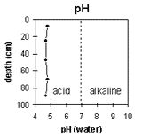 | 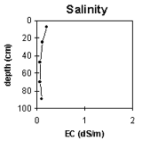 | 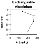 | 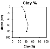 |
The soil profile is very strongly acid throughout. | Soluble salt levels are very low throughout the profile. | The exchangeable aluminium levels are high throughout the profile. | The clay % increases gradually down the profile. |
Horizon | Horizon Depth (cm) | pH (water) | pH (CaCl2) | EC 1:5 | Exchangeable Cations | |||
Ca | Mg | K | Na | |||||
meq/100g | ||||||||
A11 | 0-15 | 4.8 | 4.3 | 0.2 | 5.1 | 1.4 | 0.5 | 0.1 |
A12 | 15-35 | 4.7 | 4.0 | 0.11 | 2.2 | 1.2 | 0.3 | 0.1 |
B21 | 35-60 | 4.7 | 4.0 | 0.06 | 1.7 | 1.7 | 0.2 | 0.1 |
B22 | 60-80 | 4.8 | 4.0 | 0.06 | 1.5 | 2 | 0.2 | 0.1 |
B23 | 80-100 | 4.7 | 3.9 | 0.09 | 1.4 | 2.4 | 0.2 | 0.1 |
Horizon | Horizon Depth (cm) | Exchangeable Aluminium mg/kg | Exchangeable Acidity meq/100g | Field Capacity pF2.5 | Wilting Point pF4.2 | Coarse Sand (0.2-2.0 mm) | Fine Sand (0.02-0.2 mm) | Silt (0.002-0.02 mm) | Clay (<0.002 mm) |
A11 | 0-15 | 140 | 20 | 38 | 17 | 1 | 24 | 39 | 28 |
A12 | 15-35 | 270 | 18.8 | 33 | 18 | 0 | 21 | 39 | 37 |
B21 | 35-60 | 260 | 18 | 34 | 19 | 0 | 20 | 39 | 39 |
B22 | 60-80 | 220 | 18 | 34 | 19 | 0 | 18 | 35 | 46 |
B23 | 80-100 | 200 | 20.4 | 0 | 22 | 33 | 42 |
Management Considerations:
Whole Profile
- Plant Available Water Capacity (PAWC) is considered to be low-medium (estimated at approximately 98 mm). This is based on available laboratory data and assumes an effective rooting depth at 100 cm. Rooting depth is restricted by the siltstone base.
- These soils are generally highly permeable.
- The very strongly acid surface soil indicates that aluminium and manganese toxicity may occur. The level of exchangeable aluminium measured by the laboratory is quite high for the surface (A1) horizons. At these levels the growth of aluminium sensitive species such as phalaris and medics may be restricted. Raising the pH level of the soil by liming will help reduce the level of exchangeable aluminium. A lime test (sampled across the paddock) may be appropriate to determine the amount of lime required to raise pH levels. Other factors need to be considered before lime is recommended e.g pasture species grown, method of application, local trial responses, soil surface structure and likely cost/benefit. However, lime application may not be possible because of the terrain.
- In strongly acid surface soils, deficiencies in molybdenum and phosphorus may also occur. This can also be treated by adding lime. High levels of aluminium will tend to "fix" phosphorus and make it unavailable to plants. Increasing soil pH will enable phosphorus to be more available from superphosphate application. The optimum pH range for phosphorus availability is between pH 6.0-6.5. The addition of molybdenum may be required for pasture growth. Plant tissue analysis may give a more accurate assessment of molybdenum requirements.
- Surface soils in the Strzelecki hills generally have higher potassium levels than other soils in South Gippsland. This is due to the high feldspar content of the parent material.
- The exchangeable aluminium level increases to a very high level in the subsurface (A12) horizon. At these levels the growth of a number of aluminium sensitive species may be restricted e.g. sub clover, white clover, tall fescue, ryegrass and cocksfoot.
- Exchangeable aluminium levels are still very high in the subsoil.
- The subsoil will be relatively well drained as there isn't a sharp increase in clay content at the A/B horizon boundary. The subsoil horizons are non-sodic and are not coarsely structured which will enable plant roots to penetrate without significant restrictions (unless the plants are aluminium sensitive).
- On steep slopes, lateral movement of water may occur above the bedrock which may precipitate soil slumping. In shallow drainage lines, tunnel erosion may occur just above the bedrock. Ultimately these tunnels may collapse to form gullies.
- Never ploughed or cropped due to steep slope.