Victorian Resources Online (archived)
SG3
|
Location: Inverloch | Australian Soil Classification: Parapanic, Humosesquic, Semiaquic PODOSOL; (f Grey KUROSOL) |
| Northcote Factual Key: Dy 3.41 | Great Soil Group: podzol |
| Geology: Tertiary sandstone (fluviatile). | General Landscape Description: Crest of a slight rise on a gently undulating plain. |
| Soil Mapping Unit: Leongatha South. | Site Description: Grazing paddock near Inverloch. |
| Native Vegetation: Includes Swamp Gum (Eucalyptus ovata) and Swamp Paperbark (M. ericifolia). | |
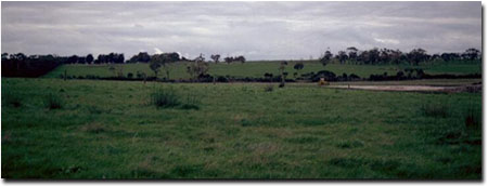 Soil Site SG3 Landscape |
Soil Profile Morphology:
Surface Soil
| 0 | 0-4 cm | Organic matter mat. | 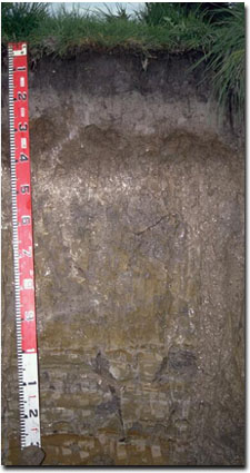 Site SG3 Profile |
| A1 | 4-20 cm | Dark grey (10YR4/1); fine sandy clay loam; weak coarse blocky structure; firm consistence dry; pH 5.1; abrupt change to: | |
| A2 | 20-30 cm | Light brownish grey (10YR6/2); conspicuously bleached (10YR8/1d); very fine sandy clay loam; massive; strong consistence dry; pH 5.3; clear and wavy change to: | |
| Subsoil | |||
| Bhs | 30-45 cm | Yellowish brown (10YR5/4); fine sandy clay loam; very strong consistence dry; indurated with variably cemented brown (7.5YR4/6) "coffee rock" which forms a discontinuous layer; pH 5.8; clear change to: | |
| 2A2 | 45-55 cm | Light brownish grey (10YR6/2) conspicuously bleached (10YR8/1d); fine sandy loam; strong consistence dry; massive; pH 6.1; clear change to: | |
| 2B21 | 55-80 cm | Light brownish grey (10YR6/2) with strong brown (7.5YR5/8) mottles; light clay; strongly structured; firm consistence moist; pH 5.4; gradual change to: | |
| 2B22 | 80-100 cm | Light brownish grey (10YR6/2) with strong brown (7.5YR5/8) mottles; medium clay; strongly structured; pH 5.3; sharp change to: | |
| C | 100+ cm | Weathered sandstone. | |
Note: It appears that the Podosol is forming in the A horizon of an older Grey Kurosol.
Key Profile Features:
- Accumulation of iron and organic compounds (i.e. "coffee rock") in the subsoil.
Soil Profile Characteristics:
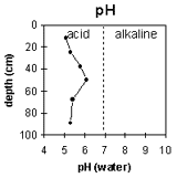 | 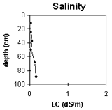 | 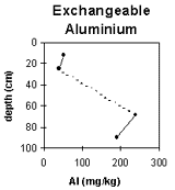 | 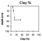 |
The pH is strongly acid throughout most of the soil profile. | Soluble salt levels are very low throughout the soil profile. | Exchangeable aluminium levels are high in the B horizons (from 55 cm depth in the profile). | Clay increases significantly in the B horizon. |
Horizon Depth (cm) | pH (water) | pH CaCl2 | EC 1:5 | Exchangeable Cations meq/100g | Ex. Al mg/kg | Ex. Acidity meq/100g | Field Capacity pF 2.5 | Wilting Point pF 4.2 | Coarse Sand (0.2-2.0 mm) | Fine Sand (0.02-0.2 mm) | Silt (0.002-0.02 mm) | Clay (<0.002 mm) | ||||
Ca | Mg | K | Na | |||||||||||||
O | 0-4 | |||||||||||||||
A1 | 4-20 | 5.1 | 3.9 | <0.05 | 3.2 | 0.7 | 0.2 | 0.1 | 51 | 13.6 | 29.2 | 6.8 | 8 | 48 | 31 | 7 |
A2 | 20-30 | 5.3 | 4.2 | <0.05 | 0.7 | 0.1 | 0.1 | <0.1 | 40 | 3 | 17.9 | 2.8 | 8 | 50 | 33 | 9 |
Bhs | 30-45 | 5.8 | 4.8 | 0.06 | 1.6 | 0.5 | 0.2 | 0.2 | ||||||||
2A2 | 45-55 | 6.1 | 4.5 | <0.05 | 0.5 | 0.7 | 0.1 | 0.2 | 8 | 51 | 30 | 13 | ||||
2B21 | 55-80 | 5.4 | 4.1 | 0.14 | 1.4 | 6.9 | 0.2 | 2.2 | 240 | 9.2 | 7 | 36 | 22 | 34 | ||
2B22 | 80-100 | 5.3 | 4.1 | 0.17 | 1.6 | 11 | 0.2 | 4.2 | 190 | 11.4 | ||||||
Management Considerations:
Whole Profile
- Plant Available Water Capacity (PAWC) is considered to be very low (estimated at approximately 35 mm). This is based on available laboratory data and assumes an effective rooting depth of 30 cm. Rooting depth will be restricted by the "coffee rock" layer.
Surface (A) Horizons
- The surface (A1 and A2) horizons are strongly acid. However, the exchangeable aluminium level is not high in this profile and is therefore unlikely to restrict plant growth. A pH/aluminium test sampled across the paddock may be appropriate to determine whether lime is needed to raise the surface soil pH. Other factors need to be considered before lime is recommended (e.g pasture species grown, method of application, local trial responses, soil surface structure and likely cost/benefit).
- Deficiencies in molybdenum, phosphorus and potassium may occur in the strongly acid surface horizons. If lime is required, an application may assist in alleviating molybdenum deficiency and will increase phosphorus availability, as well as increasing pH.
- Organic matter is important for maintaining soil aggregation on such soils with high fine sand (48%) and silt (31%) contents. At low organic matter levels, structural deterioration (e.g. exacerbated hardsetting, surface sealing and compaction) is more likely to occur; particularly if cultivation takes place.
Subsoil (B) Horizons
- The indurated "coffee rock" layer will restrict root and water movement.
- The subsoil horizons (from 55 cm depth) are sodic and disperse strongly in water. This is likely to further restrict root and water movement through the subsoil.
- Exchangeable aluminium levels are high in the strongly acid subsoil. This is not likely to affect the growth of plants as the effective rooting depth will be restricted by the coffee rock layer.
Comments from Landholder:
- Lime, superphosphate and potash have been applied.
Profile Described By: Mark Imhof, Ian Sargeant and Sonia Thompson (20/6/95).