Victorian Resources Online (archived)
SG4
|
Location: Wonthaggi | Australian Soil Classification: Endoacidic, Epipedal, Aquic (Black) VERTOSOL |
| Northcote Factual Key: Ug 5.1 | Great Soil Group: black clay |
| Geology: Recent alluvium derived from South Gippsland Uplands. | General Landscape Description: Interdune swale. |
| Soil Mapping Unit: Tarwin (also minor component of Heath Mounds Unit). | Site Description: Bushland reserve on Boundary Road, Wonthaggi. |
| Native Vegetation: Predominantly Swamp Paperbark (Melaleuca ericifolia). | |
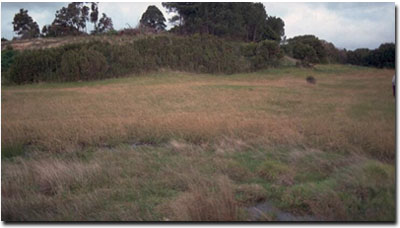 Site SG4 Landscape |
Soil Profile Morphology:
Surface Soil
| A1 | 0-20 cm | Black (10YR2/1); light clay; strong fine polyhedral structure; weakly self-mulching; surface cracking occurs when dry; weak consistence moist; pH 6.2; clear change to: | 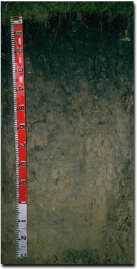 Site SG4 Profile |
| Subsoil | |||
| B21 | 20-35 cm | Black (10YR2/1); medium clay; moderate very coarse prismatic, parting to moderate coarse blocky structure; firm consistence moist; pH 6.3; clear and wavy change to: | |
| B22 | 35-70 cm | Dark grey (10YR4/1) with yellowish brown (10YR5/6) mottles; heavy clay; structure similar to above; firm consistence moist; slickensides present; pH 5.7; gradual change to: | |
| B23 | 70-105 cm | Light brownish grey (10YR6/2) with brownish yellow (10YR6/8); heavy clay; moderate very coarse prismatic, parting to strong medium to coarse blocky structure; firm consistence moist; pH 5.1; clear change to: | |
| B31 | 105+ cm | Light grey (10YR7/1) with brownish yellow (10YR6/8) mottles; fine sandy clay; firm consistence moist; pH 5.2. | |
- Clay texture throughout profile.
- Shrink-swell (i.e. vertic) properties resulting in strong cracking when dry.
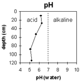 | 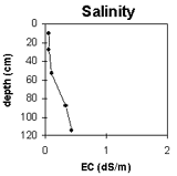 | 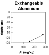 |
The surface soil and top of the subsoil are slightly acid. The pH decreases further down the profile and from 70 cm depth the soil is strongly acid. | The level of soluble salts is very low for most of the soil profile. From 105 cm the salinity rating becomes medium. | As the soil becomes strongly acid from 70 cm depth, the exchangeable aluminium levels become high. |
Horizon Depth (cm) | pH (water) | pH CaCl2 | EC 1:5 | NaCl % | Exchangeable Cations meq/100g | Ex. Al mg/kg | Ex. Acidity meq/100g | Field Capacity pF 2.5 | Wilting Point pF 4.2 | Coarse Sand (0.2-2.0 mm) | Fine Sand (0.02-0.2 mm) | Silt (0.002-0.02 mm) | Clay (<0.002 mm) | ||||
Ca | Mg | K | Na | ||||||||||||||
A1 | 0-20 | 6.2 | 5.1 | 0.06 | 7.3 | 7.4 | 1.0 | 0.5 | 38.8 | 18.9 | 6 | 32 | 21 | 30 | |||
B21 | 20-35 | 6.3 | 4.8 | 0.06 | 4.6 | 9.6 | 0.7 | 1.2 | 12.7 | 36.9 | 19.8 | 5 | 28 | 19 | 41 | ||
B22 | 35-70 | 5.7 | 4.4 | 0.11 | 2.5 | 9.7 | 0.5 | 2.0 | 13.2 | ||||||||
B23 | 70-105 | 5.1 | 4.3 | 0.34 | 0.08 | 2.0 | 12 | 0.4 | 3.9 | 280 | 14 | ||||||
B31 | 105+ | 5.2 | 4.4 | 0.44 | 0.12 | 1.9 | 12 | 0.3 | 6.4 | 160 | 11 | ||||||
Management Considerations:
Whole Profile
- Deep cracking occurs when the soil is dry. This will allow heavy rains to move down to the subsoil. When wet, the soil will swell and further infiltration of water will be relatively slow. Waterlogging will occur in winter as a result. Much of the soil profile will be saturated for a prolonged period (i.e. 2-3 months) of the year.
- Plant Available Water Capacity (PAWC) is considered to be low (estimated at approximately 85 mm). This is based on available laboratory data and assumes an effective rooting depth of 70 cm.
Surface (A) Horizons
- Tillage or overstocking of cracking clay soils should be avoided if the soil is wet (i.e. wetter than the plastic limit). At such moisture conditions, tillage and excessive trafficking or over-stocking could result in structural damage (e.g. compaction, smearing) occurring. Ideally, tillage and trafficking should take place when the soil is drier than the plastic limit down to at least the tillage depth.
Subsoil (B) Horizons
- From approximately 70 cm depth the subsoil becomes strongly acid. As a result, aluminium toxicity may occur. The level of exchangeable aluminium measured in the laboratory is high and likely to restrict the growth of deeper-rooted aluminium sensitive species.
- In the deeper subsoil, the level of soluble salts increases to levels which may affect deeper-rooted salt sensitive species. The salt problem is below effective rooting depth but could be monitored over time.
- The subsoil is likely to have strong vertic properties which indicates that significant shrinking and swelling occurs on wetting and drying. This can disrupt the roots of perennial plants and will have implications for engineering applications (e.g. building foundations).