Victorian Resources Online (archived)
SG7
| Location: Koonwarra | Australian Soil Classification: Bleached-Mottled, Eutrophic (nearly Magnesic), Brown KUROSOL |
| Northcote Factual Key: Dy 3.41 | Great Soil Group: soloth |
| Geology: Cretaceous sediments. | General Landscape Description: Crest of a low hill (3-8% slope). |
| Soil Mapping Unit: Koonwarra | Site Description: Cleared but uncultivated area near Koonwarra. |
| Native Vegetation: Includes Narrow leafed peppermint (Eucalyptus radiata) and Messmate (E. obliqua). | |
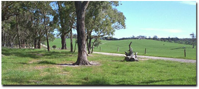 Site SG7 Landscape |
Soil Profile Morphology:
| Surface Soil | 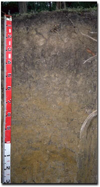 Site SG7 Profile | ||
| A1 | 0-10 cm | Black (10YR2/1); light silty clay loam; weak blocky structure; hardsetting surface condition; weak consistence moist; pH 5.5; abrupt change to: | |
| A2 | 10-25 cm | Greyish brown (10YR5/2) (with some yellowish brown); conspicuously bleached; light silty clay loam; weak coarse blocky structure; very strong consistence dry; pH 5.3; sharp change to: | |
| Subsoil | |||
| B21 | 25-55 cm | Brown (10YR5/3) with yellowish brown (10YR5/8) mottles; heavy clay; strong coarse prismatic, parting to strong coarse blocky structure; dark stains present on ped faces; very firm consistence moist; pH 5.4; clear change to: | |
| B22 | 55-100 cm | Greyish brown (10YR5/2) with strong brown (7.5YR5/8) mottles; heavy clay; strong fine polyhedral structure (with shiny faced peds); pH 5.5; gradual change to: | |
| B31 | 100-120 cm | Reddish yellow (7.5YR6/8) with red (2.5YR5/8) mottles; medium heavy clay; contains a band of ferromanganiferous segregations (up to 10 mm size) at 100-110 cm depth; pH 5.4; gradual change to: | |
| B32 | 120+ cm | Reddish yellow (7.5YR6/8) and white (10YR8/1); medium heavy clay; pH 5.4. | |
Key Profile Features:
- Strong texture contrast between surface (A) and subsoil (B) horizons.
Soil Profile Characteristics:
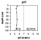 | 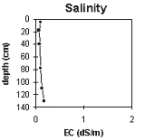 | 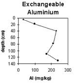 | 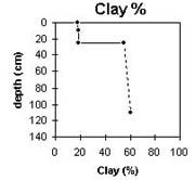 |
The soil profile is strongly acid throughout. | Levels of soluble salts are very low throughout the profile. | Exchangeable aluminium levels become high in the subsoil horizons. | The clay content increases sharply at the A/B horizon boundary, i.e. there is a strong texture contrast between surface and subsoil horizons. |
Horizon Depth (cm) | pH water | pH CaCl2 | EC 1:5 | Exchangeable Cations | Ex. Al mg/kg | Ex. Acidity meq/100g | Wilting Point pF 4.2 | Coarse Sand (0.2 - 2 mm) | Fine Sand (0.02-0.2 mm) | Silt (0.002-0.02 mm) | Clay (<0.002 mm) | ||||
Ca | Mg | K | Na | ||||||||||||
meq/100g | |||||||||||||||
A1 | 0-10 | 5.5 | 4.2 | 0.09 | 3.3 | 2.4 | 0.4 | 0.2 | 30 | 11.1 | 3 | 35 | 42 | 18 | |
A2 | 10-25 | 5.3 | 4.1 | 0.07 | 0.8 | 1.3 | 0.1 | 0.1 | 98 | 8 | 6.9 | 4 | 36 | 43 | 19 |
B21 | 25-55 | 5.4 | 4.1 | 0.08 | 1.9 | 6.7 | 0.5 | 0.8 | 230 | 21.3 | 21.6 | 2 | 16 | 25 | 55 |
B22 | 55-100 | 5.5 | 4.2 | 0.09 | 1.8 | 9.4 | 0.5 | 1.5 | 210 | 29.5 | |||||
B31 | 100-120 | 5.4 | 4.4 | 0.13 | 1.4 | 7.2 | 0.3 | 1.4 | 170 | 16.2 | |||||
B32 | 120+ | 5.4 | 4.3 | 0.17 | 2.1 | 11 | 0.5 | 2.4 | 240 | 15 | |||||
Whole Profile
- Plant Available Water Capacity (PAWC) is considered to be medium (estimated at approximately 120 mm) for the top metre of the soil profile. This is based on available laboratory data and assumes an effective rooting depth of 100 cm. If rooting depth is restricted by the coarsely structured B21 horizon, then PAWC will be significantly lower (i.e. approximately 32 mm for the A horizons).
- The exchangeable aluminium level measured in the laboratory is not high in the strongly acid surface soil. This could be due to the effect of organic matter. In the A2 horizon, the levels have increased and may affect aluminium sensitive species. A pH/aluminium test sampled across the paddock may be appropriate to determine whether lime is needed to raise the surface soil pH. Other factors need to be considered before lime is recommended (e.g pasture species grown, method of application, local trial responses, soil surface structure and likely cost/benefit).
- The surface soil has a very high silt (42%) and fine sand (35%) content. Such soils tend to be unstable when rapidly wet which can result in the formation of surface crusts upon drying. However, the organic matter content is quite high at this site which results in surface soil aggregates being water-stable. Organic matter is important for promoting soil aggregation on such soils.
- The high level of exchangeable magnesium (i.e. 38%) may induce potassium deficiency (Baker and Eldershaw, 1993). Any deficiency can be assessed by plant tissue analysis.
- In strongly acid surface soils, deficiencies in molybdenum and phosphorus may occur.
- The A2 horizon sets very hard when dry and will become "spewy" when wet.
- The clay content increases sharply at the boundary between the light silty clay loam surface soils and the heavy clay B21 horizon. The B21 horizon is also dense and coarsely structured which will result in water and root movement being restricted. The presence of a bleached A2 horizon above the subsoil indicates that water movement is being restricted. On slopes, lateral movement of water may occur along the top of the relatively less permeable subsoil.
- The cation exchange is dominated by magnesium ions. This could result in a cation imbalance (e.g. potassium and/or calcium deficiency could occur). The high level of exchangeable magnesium in relation to calcium may also contribute to poor subsoil structure.
- From 25 cm depth in the profile, the level of exchangeable aluminium measured in the laboratory is high (230 mg/kg) and may restrict the growth of many aluminium sensitive species (such as lucerne, phalaris, subclover, white clover and tall fescue) and may affect more tolerant species, such as cocksfoot and ryegrass.
- "Pugging" problems can occur in winter.
- 2.5 cows/hectare is the usual carrying capacity.
- Potash and super responses occur.