Victorian Resources Online (archived)
SG9
| Location: Bald Hills. | Australian Soil Classification: Humose, Humic/Humosesquic, Aquic PODOSOL (f. Grey KUROSOL1). |
| Northcote Factual Key: Dy 3.41. | Great Soil Group: humus podzol. |
| Geology: Quaternary sediments. | General Landscape Description: Midslope of a slight rise on a gently undulating plain (slope <1%). |
| Soil Mapping Unit: Heath Mounds. | Site Description: Bald Hills Wetland Reserve. |
| Native Vegetation: Includes Gippsland Mallee (Eucalyptus kitsoniana) and Prickly Tea-tree (Leptospermum juniperinum). | |
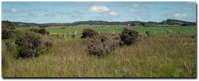 Site SG9 Landscape |
Soil Profile Morphology:
| Surface Soil | 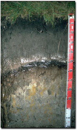 Site SG9 Profile | ||
| A11 | 0-20 cm | Black (10YR2/1); sandy loam; loose surface condition; weak fine crumb structure; pH 4.8; abrupt change to: | |
| A12 | 20-40 cm | Dark grey (10YR4/1); loamy sand; structureless; pH 5.5; clear change to: | |
| A2 | 40-50 cm | Greyish brown (10YR5/2) conspicuously bleached; sandy loam; structureless; pH 5.3; sharp change to: | |
| Subsoil | |||
| Bh | 50-55 cm | Black (10YR2/1); sandy loam; structureless; weak consistence wet; pH 4.6; abrupt and wavy change to: | |
| Bhs | 55-65 cm | Brown (10YR4/3); sandy clay loam; moderate blocky structure; contains some variably cemented "coffee rock" segregations; firm consistence wet; pH 4.6; clear change to: | |
| D21 | 65-90 cm | Grey (10YR6/1) with strong brown (7.5YR5/6) mottles; sandy loam; very weak coarse blocky structure; firm consistence wet; pH 4.8; gradual change to: | |
| D22 | 90+ cm | Grey (10YR6/1) with brownish yellow (10YR6/8) and red (2.5YR4/8) mottles; medium clay (sandy); weak coarse blocky structure; firm consistence wet; pH 4.8. | |
i) Humic Podosols generally occur on sands in areas influenced by ground water.
ii) 1 It appears that the Podosol has developed in the A horizon of an older Grey Kurosol.
Key Profile Features:
- The subsoil is saturated for a number of months of the year (i.e. Aquic)
- Subsoil accumulation of iron and organic matter (i.e. "coffee rock").
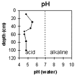 | 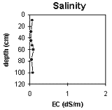 | 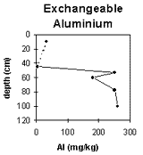 | 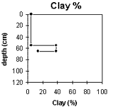 |
The surface soil is very strongly acid. The subsurface horizons are strongly acid. The subsoil (from 50 cm) is very strongly acid throughout. | Soluble salt levels are very low throughout the profile. | The exchangeable aluminium level is low in the surface horizons but becomes high in the subsoil (D) horizons (from 50 cm depth). | The clay content increases significantly at 55 cm depth. |
Horizon Depth (cm) | pH water | pH CaCl2 | EC 1:5 | Exchangeable Cations | Ex. Al mg/kg | Ex. Acidity meq/100g | Wilting Point pF 4.2 | Coarse Sand (0.2 - 2 mm) | Fine Sand (0.02-0.2 mm) | Silt (0.002-0.02 mm) | Clay (<0.002 mm) | ||||
Ca | Mg | K | Na | ||||||||||||
meq/100g | |||||||||||||||
A11 | 0-20 | 4.8 | 3.7 | 0.06 | 4.6 | 1.6 | 0.2 | 0.1 | 33 | 18.8 | 1 | 28 | 47 | 5 | 5 |
A12 | 20-40 | 5.5 | 4.0 | <0.05 | 0.3 | 0.1 | <0.1 | <0.1 | |||||||
A2 | 40-50 | 5.3 | 4.1 | <0.05 | <10 | <0.4 | |||||||||
Bh | 50-55 | 4.6 | 3.6 | 0.07 | 250 | 26.6 | 9.9 | ||||||||
Bhs | 55-65 | 4.6 | 4.0 | 0.09 | 0.6 | 1.1 | 0.2 | 0.1 | 180 | 31.4 | 17 | 17 | 32 | 7 | 38 |
D21 | 65-90 | 4.8 | 4.2 | 0.05 | 0.1 | 0.4 | 0.1 | <0.1 | 250 | 6.8 | 32 | 48 | 6 | 14 | |
D22 | 90+ | 4.8 | 4.0 | 0.08 | 1.4 | 0.4 | 0.1 | 0.1 | 260 | 9.8 | |||||
Management Considerations:
Whole Profile
- The presence of a deep water table which rises close to the surface in winter will result in the profile being saturated for a number of months. Root growth will be limited in such poorly aerated soils. Plant available water capacity (PAWC) will therefore be very low.
- The surface soil is very strongly acid but the exchangeable aluminium level measured in the laboratory is not high. A pH/aluminium test sampled across the paddock may be appropriate to determine whether lime is needed to raise the soil pH. Other factors need to be considered before lime is recommended (e.g pasture species grown, method of application, local trial responses, soil surface structure and likely cost/benefit). The pH increases in the subsurface (A12 and A2) horizons and negligible exchangeable aluminium is present.
- Deficiencies in molybdenum, phosphorus and potassium may occur in the very strongly acid surface soil. Potassium deficiency may also be induced by the high exchangeable magnesium percentage (i.e. 24%). Increasing soil pH by lime application will enable phosphorus (from superphosphate application) to be more available. If lime is required and pH is increased, the availability of major nutrients should improve.
- Trace elements such as copper and zinc are likely to be low. Plant tissue analysis may give a more accurate assessment of trace element requirements.
- Apart from the surface (A11) horizon, all the horizons below have a very low inherent fertility (based on the sum of the exchangeable basic cations).
- The exchangeable aluminium levels become high in the very strongly acid subsoil from 50 cm depth. These levels are likely to affect the growth of aluminium sensitive species.
- Inherent fertility is very low for the subsoil horizons (based on the sum of the exchangeable basic cations).
- The "coffee rock" layer is likely to result in some restriction to root and water movement.