Victorian Resources Online (archived)
GP14
| Location: Ellinbank Dairy Research Institute. | Australian Soil Classification: Bleached-Acidic, Dermosolic, Redoxic HYDROSOL. |
| Northcote Factual Key: Gn4.64. | Great Soil Group: brown podzolic. |
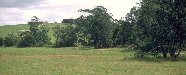
| General Site Description: Valley floor. | Geology: Quaternary unconsolidated alluvium. |
| Mapping Unit: Ripplebrook | Geographic Reference: 407043E, 5765891N |
Soil Profile Morphology:
Surface Soil
| A1 | 0-10 cm | Brown (10YR4/3); silty clay loam; strong medium blocky, parting to moderate fine blocky structure; weak consistence moist; pH 5.1; clear change to: | 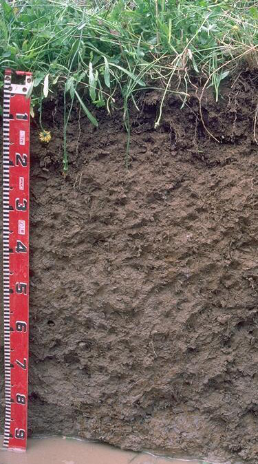 |
| A2 | 10-25 cm | Yellowish brown (10YR5/4) conspicuously bleached (10YR8/2d); silty clay loam; moderate medium blocky, parting to moderate fine subangular blocky structure; weak consistence moist; pH 5.0; clear and wavy change to: | |
| Subsoil | |||
| B21 | 25-75 cm | Pale brown (10YR6/3) with faint brownish yellow (10YR6/6) mottles; silty clay loam (becoming light clay with depth); moderate medium blocky, parting to moderate fine blocky structure; firm consistence moist; contains very few (2%) soft manganese segregations; pH 5.0; clear and wavy change to: | |
| B22 | 75-90 cm | Light brownish grey (10YR6/2) with yellowish brown (10YR5/8) mottles; light medium clay; moderate coarse blocky, parting to moderate fine blocky structure; firm consistence moist; contains few (5%) soft manganese segregations; pH 5.4. | |
Key Profile Features:
- Lack of strong texture contrast between surface (A) horizons and upper subsoil (B21) horizon (i.e. Dermosolic).
- Much of the soil profile is saturated for prolonged periods (i.e. several months per year) in most years.
Soil Profile Characteristics:
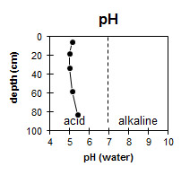 | 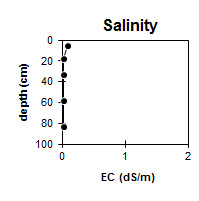 |  |
| The soil profile is strongly acid throughout. | The level of soluble salts are very low throughout the profile. | The soil profile is non-sodic throughout. |
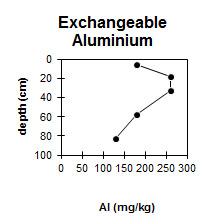 |  | |
| The level of exchangeable aluminium is quite high in the strongly acid surface horizons and upper subsoil. | There is negligible change in clay content with depth. |
Horizon | Horizon Depth (cm) | pH water | pH CaCl2 | EC dS/m | Exchangeable Cations | Exchangeable Aluminium mg/kg | Field Capacity pF 2.5 | Wilting Point pF 4.2 | Coarse Sand (0.2 -2.0 mm) | Fine Sand (0.02-0.2 mm) | Silt (0.002-0.02 mm) | Clay (<0.002 mm) | |||
Ca | Mg | K | Na | ||||||||||||
meq/100 g | |||||||||||||||
A1 | 0-10 | 4.4 | 5.1 | 0.08 | 2.8 | 1.1 | 0.43 | 0.17 | 180 | 39 | 12.5 | 2 | 23 | 50 | 26 |
A2 | 10-25 | 4.2 | 5 | <0.05 | 1.7 | 0.52 | 0.3 | 0.09 | 260 | 37.3 | 10.4 | 1 | 24 | 51 | 27 |
B21 | 25-40 | 4.2 | 5 | <0.05 | 1.7 | 0.82 | 0.27 | 0.07 | 260 | 34.1 | 10.6 | 1 | 22 | 53 | 29 |
B21 | 40-75 | 4.3 | 5.1 | <0.05 | 2.3 | 1.7 | 0.23 | 0.09 | 180 | 33.9 | 11 | 1 | 22 | 51 | 29 |
B22 | 75-90 | 4.4 | 5.4 | <0.05 | 2.9 | 2.9 | 0.28 | 0.14 | 130 | ||||||
Management Considerations:
Whole Profile
- Plant available water capacity (PAWC) is considered to be low (estimated at 80 mm) for the top metre of the soil profile. This is based on available laboratory data. A significant proportion (35 mm) of the plant available water is held in the surface (A) horizons.
- Much of the soil profile is likely to be saturated for prolonged periods (i.e. several months) in most years (i.e. Hydrosol). Subsurface drainage may be a viable management option for such soils. Tile drains placed at 1-2 m depth and with 20-30 m spacing has proved successful on some soils in the region (Frank Mickan, pers. comm.).
- The levels of exchangeable aluminium are quite high in the strongly acid surface horizons (180 - 260 mg/kg). These levels are likely to restrict the growth of aluminium sensitive species. A pH/aluminium test sampled from across the paddock would be most appropriate to determine whether lime is needed to raise soil pH. Other factors need to be considered, however, before lime is recommended (e.g. pasture species grown, method of application, local trial responses, soil surface structure and likely cost/benefit).
- Manganese toxicity may also occur in strongly acid soils, particularly when poorly drained (as waterlogging may bring manganese into solution).
- Deficiencies in molybdenum, potassium and phosphorus are likely to occur in strongly acid soils. If lime is required, an application may assist in alleviating molybdenum deficiency and will increase phosphorus availability, as well as increasing soil pH. Phosphorus tends to become 'fixed' by high levels of exchangeable aluminium.
- The surface soil has a very high silt (50%) and fine sand (23%) content. Organic matter is important for maintaining aggregation on such soils. At low organic matter levels, structural deterioration (e.g. exacerbated hardsetting, surface sealing and compaction) is more likely to occur, particularly if cultivation takes place. The surface soil is likely to suffer structural degradation (e.g. pugging, compaction) if overstocking occurs whilst the soil is wet.
- The surface soil has a low nutrient status (based on the sum of the basic exchangeable cations).
- Exchangeable aluminium levels remain high throughout the strongly acid subsoil.
- The upper subsoil has a low inherent fertility (based on the sum of the basic exchangeable cations).
- Root growth may be restricted by seasonal saturation of the subsoil.